
Make a donation
Gear up for your next adventure:
As an Amazon Associate, this site earns from qualifying purchases at no extra cost to you.
Glaaien topographic map
Click on the map to display elevation.
Make a donation
Gear up for your next adventure:
As an Amazon Associate, this site earns from qualifying purchases at no extra cost to you.
Glaaien
Glaaien ligt in het dal van de Jeker op een hoogte van 79 meter. Aan beide zijden daarvan neemt de hoogte snel toe, en bereikt men het open landschap van droog-Haspengouw.
Make a donation
Gear up for your next adventure:
As an Amazon Associate, this site earns from qualifying purchases at no extra cost to you.
About this map
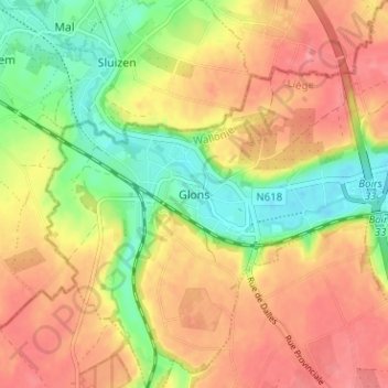
Name: Glaaien topographic map, elevation, terrain.
Location: Glaaien, Luik, Wallonië, 4450, België (50.73167 5.52358 50.77167 5.56358)
Average elevation: 390 ft
Minimum elevation: 249 ft
Maximum elevation: 502 ft
Make a donation
Gear up for your next adventure:
As an Amazon Associate, this site earns from qualifying purchases at no extra cost to you.
Other topographic maps
Click on a map to view its topography, its elevation and its terrain.
Beyne-Heusay
Beyne-Heusay ligt in het Land van Herve op een hoogte van ongeveer 200 meter. De omgeving is sterk verstedelijkt, wat een gevolg is van de steenkoolwinning en de nabijheid van de Luikse agglomeratie. Enkele landgoedbossen, zoals Bois de Beyne, zijn echter nog aanwezig.
Average elevation: 574 ft
Make a donation
Gear up for your next adventure:
As an Amazon Associate, this site earns from qualifying purchases at no extra cost to you.
Herstal
De stad ligt in het laagterras van de Maas, op een hoogte van ongeveer 70 meter. Naar het westen toe neemt de hoogte toe tot 145 meter, en is men in Haspengouw. In het noorden wordt Herstal begrensd door de autoweg A3. De Spoorlijn 34 doorsnijdt Herstal.
Average elevation: 371 ft
Make a donation
Gear up for your next adventure:
As an Amazon Associate, this site earns from qualifying purchases at no extra cost to you.