
Beyne-Heusay topographic map
Interactive map
Click on the map to display elevation.
About this map
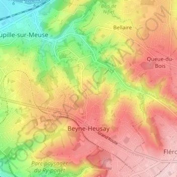
Name: Beyne-Heusay topographic map, elevation, terrain.
Location: Beyne-Heusay, Luik, Wallonië, 4610, België (50.61112 5.63549 50.65086 5.69361)
Average elevation: 574 ft
Minimum elevation: 184 ft
Maximum elevation: 879 ft
Beyne-Heusay ligt in het Land van Herve op een hoogte van ongeveer 200 meter. De omgeving is sterk verstedelijkt, wat een gevolg is van de steenkoolwinning en de nabijheid van de Luikse agglomeratie. Enkele landgoedbossen, zoals Bois de Beyne, zijn echter nog aanwezig.
Other topographic maps
Click on a map to view its topography, its elevation and its terrain.
Plainevaux
Plainevaux, Neupré, Luik, Wallonië, 4120, België
Average elevation: 719 ft
Villers-Saint-Siméon
België > Luik > Luik > Villers-Saint-Siméon
Villers-Saint-Siméon, Luik, Wallonië, 4453, België
Average elevation: 499 ft
Grâce-Hollogne
België > Luik > Luik > Grâce-Hollogne
Grâce-Hollogne, Luik, Wallonië, 4460, België
Average elevation: 469 ft
Remouchamps
België > Luik > Luik > Aywaille
Remouchamps, Aywaille, Luik, Wallonië, 4920, België
Average elevation: 728 ft
Embourg
België > Luik > Luik > Chaudfontaine
Embourg, Chaudfontaine, Luik, Wallonië, 4050, België
Average elevation: 456 ft
Chaudfontaine
Chaudfontaine, Luik, Wallonië, 4050, België
Average elevation: 617 ft
Rotheux-Rimière
België > Luik > Luik > Rotheux-Rimière
Rotheux-Rimière, Neupré, Luik, Wallonië, 4120, België
Average elevation: 764 ft