
Campbell Junction topographic map
Click on the map to display elevation.
About this map
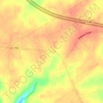
Name: Campbell Junction topographic map, elevation, terrain.
Average elevation: 1,962 ft
Minimum elevation: 1,818 ft
Maximum elevation: 2,021 ft
Other topographic maps
Click on a map to view its topography, its elevation and its terrain.
Fairfield Glade
United States > Tennessee > Cumberland County > Fairfield Glade
Average elevation: 1,778 ft
Crossville
United States > Tennessee > Cumberland County
Crossville occupies a high, gently rolling upland position on Tennessee’s Cumberland Plateau, giving the city a broad plateau character rather than a sharply mountainous one. Around the town center, elevations cluster near about 1,800–1,900 ft (550–580 m), with the surrounding landscape rising and…
Average elevation: 1,814 ft
Cumberland Mountain State Park
United States > Tennessee > Cumberland County > Crossville
Average elevation: 1,818 ft
Crossville
United States > Tennessee > Cumberland County
Crossville occupies a high, gently rolling upland position on Tennessee’s Cumberland Plateau, giving the city a broad plateau character rather than a sharply mountainous one. Around the town center, elevations cluster near about 1,800–1,900 ft (550–580 m), with the surrounding landscape rising and…
Average elevation: 1,814 ft