Make a donation
Gear up for your next adventure:
As an Amazon Associate, this site earns from qualifying purchases at no extra cost to you.
Zapatoca topographic map
Click on the map to display elevation.
Make a donation
Gear up for your next adventure:
As an Amazon Associate, this site earns from qualifying purchases at no extra cost to you.
Zapatoca
Zapatoca (Spanish pronunciation: [sapaˈtoka]) is a town and municipality in the Santander Department in northeastern Colombia. It is at a high altitude and is a common stop between Bucaramanga and San Gil. It was built in the early 17th century by the Spanish conquistadores.
Make a donation
Gear up for your next adventure:
As an Amazon Associate, this site earns from qualifying purchases at no extra cost to you.
About this map
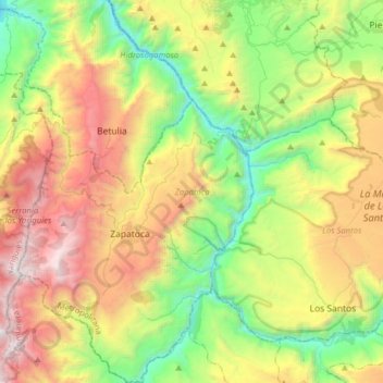
Name: Zapatoca topographic map, elevation, terrain.
Average elevation: 4,196 ft
Minimum elevation: 761 ft
Maximum elevation: 9,613 ft
Make a donation
Gear up for your next adventure:
As an Amazon Associate, this site earns from qualifying purchases at no extra cost to you.
Other topographic maps
Click on a map to view its topography, its elevation and its terrain.
Mirador del Cañon del Chicamocha
Colombia > Santander > Jordán > Villanueva
Average elevation: 3,737 ft
Make a donation
Gear up for your next adventure:
As an Amazon Associate, this site earns from qualifying purchases at no extra cost to you.
Make a donation
Gear up for your next adventure:
As an Amazon Associate, this site earns from qualifying purchases at no extra cost to you.
Make a donation
Gear up for your next adventure:
As an Amazon Associate, this site earns from qualifying purchases at no extra cost to you.
Floridablanca
Colombia > Santander > Floridablanca > Floridablanca
Floridablanca is situated at an altitude of about 925 metres (3,035 ft) in the Eastern Ranges of the Colombian Andes, though locally the topography varies greatly. To the east of the city the higher mountains of the Andes rise above the city, thrusted upwards by the north–south-trending Bucaramanga-Santa…
Average elevation: 3,579 ft
Make a donation
Gear up for your next adventure:
As an Amazon Associate, this site earns from qualifying purchases at no extra cost to you.
