
Make a donation
Gear up for your next adventure:
As an Amazon Associate, this site earns from qualifying purchases at no extra cost to you.
Todenfeld topographic map
Click on the map to display elevation.
Make a donation
Gear up for your next adventure:
As an Amazon Associate, this site earns from qualifying purchases at no extra cost to you.
Todenfeld
Der Ort liegt rund 6 km südlich der Rheinbacher Kernstadt an der L492 auf den Höhen der nördlichen Eifel im Ahrgebirge unmittelbar an der Landesgrenze zu Rheinland-Pfalz. Nachbarorte sind im Südosten Bad Neuenahr-Ahrweiler, Südwesten Bad Münstereifel, Nordwesten Euskirchen und Nordosten Meckenheim. Die nächstgelegenen Bahnhöfe sind Rheinbach und Meckenheim an der Bahnstrecke der Voreifelbahn Bonn-Euskirchen, und die nächste Autobahnanschlussstelle ist Rheinbach/ Meckenheim an der A 61.
Make a donation
Gear up for your next adventure:
As an Amazon Associate, this site earns from qualifying purchases at no extra cost to you.
About this map
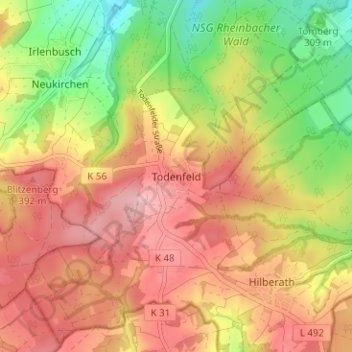
Name: Todenfeld topographic map, elevation, terrain.
Average elevation: 1,099 ft
Minimum elevation: 781 ft
Maximum elevation: 1,348 ft
Make a donation
Gear up for your next adventure:
As an Amazon Associate, this site earns from qualifying purchases at no extra cost to you.
Other topographic maps
Click on a map to view its topography, its elevation and its terrain.
Wormersdorf
Deutschland > Nordrhein-Westfalen > Rhein-Sieg-Kreis > Rheinbach
Average elevation: 696 ft
Make a donation
Gear up for your next adventure:
As an Amazon Associate, this site earns from qualifying purchases at no extra cost to you.