Geolocate

Valles Caldera topographic map

Click on the map to display elevation.

About this map

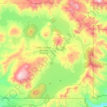
Name: Valles Caldera topographic map, elevation, terrain.

Location: Valles Caldera, Sandoval County, New Mexico, United States (35.82462 -106.64280 35.99318 -106.40282)

Average elevation: 9,094 ft

Minimum elevation: 7,260 ft

Maximum elevation: 11,417 ft

Sandoval County trails, hiking, mountain biking, running and outdoor activities

Other topographic maps

Click on a map to view its topography, its elevation and its terrain.

Seven Springs

United States > New Mexico > Sandoval County

Average elevation: 8,327 ft

Placitas

United States > New Mexico > Sandoval County

Average elevation: 6,115 ft

Placitas

United States > New Mexico > Sandoval County

Average elevation: 6,115 ft

La Cueva

United States > New Mexico > Sandoval County

Average elevation: 8,104 ft

Redondo Peak

United States > New Mexico > Sandoval County

Average elevation: 10,476 ft

San Luis

United States > New Mexico > Sandoval County

Average elevation: 6,296 ft

Cabezon

United States > New Mexico > Sandoval County

Average elevation: 6,194 ft

Gear up for your next adventure:

🔪Outdoor Multitools - Essential survival tools for gear repair and field use
🎒Trekking Poles - Sturdy poles for balance and stability on rough terrain
🧭Compass with Lanyard - Easy‑carry compass for navigation
🦶Carbon Trekking Poles - Reduce knee impact on steep descents with ultra-light poles
📡Handheld GPS Device - Reliable handheld GPS for outdoor navigation

As an Amazon Associate, this site earns from qualifying purchases at no extra cost to you.