
Make a donation
Gear up for your next adventure:
As an Amazon Associate, this site earns from qualifying purchases at no extra cost to you.
Llallagua topographic map
Click on the map to display elevation.
Make a donation
Gear up for your next adventure:
As an Amazon Associate, this site earns from qualifying purchases at no extra cost to you.
About this map
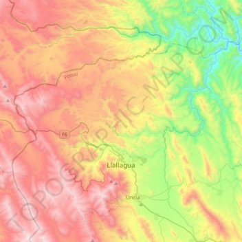
Name: Llallagua topographic map, elevation, terrain.
Location: Llallagua, Provincia Rafael Bustillo, Potosí, Bolivia (-18.47129 -66.74075 -18.25530 -66.39624)
Average elevation: 13,189 ft
Minimum elevation: 10,827 ft
Maximum elevation: 15,686 ft
Make a donation
Gear up for your next adventure:
As an Amazon Associate, this site earns from qualifying purchases at no extra cost to you.
Other topographic maps
Click on a map to view its topography, its elevation and its terrain.
Machacamarca de Potosi
Bolivia > Potosí > Provincia Rafael Bustillo > Municipio Uncía
Average elevation: 13,133 ft
Chayanta
Bolivia > Potosí > Provincia Rafael Bustillo > Municipio Chayanta
Average elevation: 12,270 ft
Estancia Ucuri
Bolivia > Potosí > Provincia Rafael Bustillo > Municipio Uncía
Average elevation: 12,805 ft
Amaya Pampa
Bolivia > Potosí > Provincia Rafael Bustillo > Municipio Chayanta
Average elevation: 13,274 ft
Make a donation
Gear up for your next adventure:
As an Amazon Associate, this site earns from qualifying purchases at no extra cost to you.
Chuquihuta
Bolivia > Potosí > Provincia Rafael Bustillo > Municipio Uncía
Average elevation: 12,434 ft
Make a donation
Gear up for your next adventure:
As an Amazon Associate, this site earns from qualifying purchases at no extra cost to you.