
Make a donation
Gear up for your next adventure:
As an Amazon Associate, this site earns from qualifying purchases at no extra cost to you.
Eastern Development Region topographic map
Click on the map to display elevation.
Make a donation
Gear up for your next adventure:
As an Amazon Associate, this site earns from qualifying purchases at no extra cost to you.
About this map
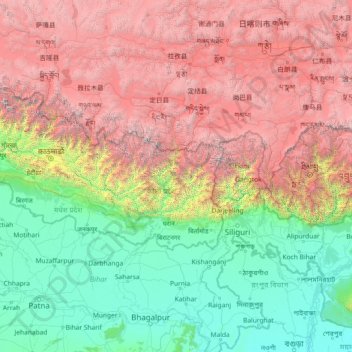
Name: Eastern Development Region topographic map, elevation, terrain.
Location: Eastern Development Region, Nepal (24.81597 84.80629 30.01597 90.00629)
Average elevation: 8,009 ft
Minimum elevation: 30 ft
Maximum elevation: 27,621 ft
Make a donation
Gear up for your next adventure:
As an Amazon Associate, this site earns from qualifying purchases at no extra cost to you.
Other topographic maps
Click on a map to view its topography, its elevation and its terrain.
Kathmandu Valley
Kathmandu valley is bowl-shaped. Its central lower part stands at 1,425 metres (4,675 ft) above sea level. Kathmandu valley is surrounded by four mountain ranges: Shivapuri hills (at an elevation of 2,732 metres or 8,963 feet), Phulchowki (2,695 metres or 8,842 feet), Nagarjun (2,095 metres or 6,873 feet) and…
Average elevation: 5,233 ft
Make a donation
Gear up for your next adventure:
As an Amazon Associate, this site earns from qualifying purchases at no extra cost to you.
Rasuwa
Its territory has elevations ranging from 614 to 7,227 meters (2,014 to 23,711 ft) from mean sea Level. Forests cover 31.43% of the land while 16.63% is always snow-covered. Steeply varying territory and plenty of natural blessings make Rasuwa a well-known tourist destination in Nepal. Sightseeing places…
Average elevation: 11,991 ft
Make a donation
Gear up for your next adventure:
As an Amazon Associate, this site earns from qualifying purchases at no extra cost to you.
Kathmandu Metropolitan City
Nepal > Bagamati Province > Kathmandu
Kathmandu (Nepali: [ˈkaʈʰmaɳɖu]) is the capital and largest city of Nepal, situated in the central part of the country within the Kathmandu Valley. As per the 2021 Nepal census, it has a population of 845,767 residing in 105,649 households, with approximately 4 million people in the surrounding…
Average elevation: 4,354 ft
Make a donation
Gear up for your next adventure:
As an Amazon Associate, this site earns from qualifying purchases at no extra cost to you.
Darchula District (Nepal)
Nepal > Sudurpashchim Province
The Himalayan region between two rivers Kali River to Seti River calls Gurans Himal. Darchula district falls in the Gurans Himal zone. Api Himal (7,132 metres (23,399 ft)) and Jethi Bahurani (6,850 metres (22,470 ft)) are main mountain peaks of the area. There is a protected area named Api Nampa Conservation…
Average elevation: 11,112 ft
Make a donation
Gear up for your next adventure:
As an Amazon Associate, this site earns from qualifying purchases at no extra cost to you.
Sankhuwasabha
The Arun River enters from Tibet at an elevation of about 3,500 meters (11,500 feet) and flows south across the district, forming one of the world's deepest valleys relative to 8,481 meter Makalu to the west and 8,586 meter Kangchenjunga to the east.
Average elevation: 9,652 ft
Siraha
Nepal > Madhesh Province > Siraha
Siraha (Nepali: सिराहा, sirāhā) is the headquarters and municipality of Siraha District, a part of Madhesh Province, Nepal. Siraha had a population of 28,442 according to the census of 2011. and a population of 82,531 as of 2015. The current population of Siraha municipality as of census 2022, is…
Average elevation: 256 ft
Make a donation
Gear up for your next adventure:
As an Amazon Associate, this site earns from qualifying purchases at no extra cost to you.
Kathmandu Metropolitan City
Nepal > Bagamati Province > Kathmandu
Kathmandu (Nepali: [ˌkaʈʰmaɳˈɖu]) is the capital and largest city of Nepal, situated in the central part of the country within the Kathmandu Valley. As per the 2021 Nepal census, it has a population of 845,767 residing in 105,649 households, with approximately 4 million people in the surrounding…
Average elevation: 4,354 ft
Make a donation
Gear up for your next adventure:
As an Amazon Associate, this site earns from qualifying purchases at no extra cost to you.
Bagamati Province
Bagmati Province has an area of 20,300 km2 which is about 13.79% of the total area of Nepal. The elevation of the province ranges from 141 m at Golaghat in Chitwan District to 7,422m at Ganesh Himal. The province has an altitude low enough to support deciduous, coniferous, and alpine forests and woodlands.…
Average elevation: 6,946 ft
Sindhuli
Mahabharat Hills (Lower Himalayan Range) occupy the northern belt of the district. The highest point of the district, Phikkal Peak with an elevation of 2,386 meters above sea level, lies in this region.
Average elevation: 2,992 ft
Make a donation
Gear up for your next adventure:
As an Amazon Associate, this site earns from qualifying purchases at no extra cost to you.
Make a donation
Gear up for your next adventure:
As an Amazon Associate, this site earns from qualifying purchases at no extra cost to you.
Make a donation
Gear up for your next adventure:
As an Amazon Associate, this site earns from qualifying purchases at no extra cost to you.
Baglung
Baglung is surrounded by Parbat, Myagdi, Rukum, Rolpa, Pyuthan and Gulmi districts. It has 59 Village Development Committees and one Municipality. Baglung has the moniker "District of suspension bridges" as there are numerous suspension bridges. It is a hilly district, and most of the population settled on the…
Average elevation: 7,628 ft
Make a donation
Gear up for your next adventure:
As an Amazon Associate, this site earns from qualifying purchases at no extra cost to you.
Dolpa
Dolpa is the largest district of Nepal covering 5.36% of the total landmass of the country. It is located at 28°43’N to 29°43’N latitude and 82°23’E to 83°41’E longitude. Elevation ranges from 1,525 to 7,625 m (5,003 to 25,016 ft). The district borders Tibet on the north and northeast, Jumla and…
Average elevation: 14,944 ft
Jhapa
Jhapa receive 250 to 300 cm of rainfall a year, and mostly during the monsoon season in the summer, and its hilly northern area receives more rainfall than the south. The maximum temperature recorded is 42.5 °C in summer and 1 °C in winter. The lowest elevation point is 58 meters which is the lowest land in…
Average elevation: 558 ft
Make a donation
Gear up for your next adventure:
As an Amazon Associate, this site earns from qualifying purchases at no extra cost to you.
Khotang
Geographically, Khotang is a hilly district of Eastern Nepal. It lies on the coordinates of 260° 50" N to 270° 28" N latitude and 860° 26" E to 860° 58" E longitude. Coordinates of the center is 27° 11' 60.00" N and 86° 46' 59.99" E. Total area of the district is 1,591 square kilometres (614 sq mi). The…
Average elevation: 4,321 ft
Kathmandu Valley
Nepal > Bagamati Province > Lalitpur
Kathmandu Valley is bowl-shaped. Its central lower part stands at 1,425 metres (4,675 ft). Kathmandu Valley is surrounded by five mountain ranges: Shivapuri hills (at an elevation of 2,732 metres (8,963 ft)), Phulchowki (2,762 metres or 9,062 feet), Nagarjun (2,128 metres or 6,982 feet), Champadevi (2,278…
Average elevation: 5,233 ft
Make a donation
Gear up for your next adventure:
As an Amazon Associate, this site earns from qualifying purchases at no extra cost to you.
Chitwan National Park
Chitwan National Park is the first national park of Nepal. It was established in 1973 as the Royal Chitwan National Park and was granted the status of a World Heritage Site in 1984. It covers an area of 952.63 km2 (367.81 sq mi) in the Terai of south-central Nepal. It ranges in elevation from about 100 m (330…
Average elevation: 1,257 ft
Make a donation
Gear up for your next adventure:
As an Amazon Associate, this site earns from qualifying purchases at no extra cost to you.
Jumla
Geographically, Jumla is a Himalayan mountainous region of which elevations ranges from 915 metres (3,002 ft) to 4,679 metres (15,351 ft). The Higher Himalayan Region consists of Patarasi and Kanjirowa Himalayan ranges. The major rivers in Jumla are Hima, Tila and Jawa.
Average elevation: 11,066 ft
Make a donation
Gear up for your next adventure:
As an Amazon Associate, this site earns from qualifying purchases at no extra cost to you.
Dhankuta
Dhankuta is a mid-hill district of eastern hill region of Nepal. It is situated between 26°53' to 27°19' north latitude and 87°8' to 88°33' east longitude. Total area of the district is 888.7 square kilometres (343.1 mi2) and it is located at 243 metres (9,600 in) to 629 metres (24,800 in) of elevation…
Average elevation: 3,602 ft
Make a donation
Gear up for your next adventure:
As an Amazon Associate, this site earns from qualifying purchases at no extra cost to you.
Taplejung
Geographically Taplejung is a mountainous district where the world's third highest peak Kanchenjunga (8586 m) is located. It is situated at elevation ranging from 670 metres (2,200 ft) to 8,586 metres (28,169 ft) from sea level.
Average elevation: 12,776 ft
Make a donation
Gear up for your next adventure:
As an Amazon Associate, this site earns from qualifying purchases at no extra cost to you.
Kathmandu Metropolitan City
Nepal > Bagamati Province > Kathmandu
Kathmandu (Nepali: [ˌkaʈʰmaɳˈɖu]) is the capital and largest city of Nepal, situated in the central part of the country within the Kathmandu Valley. As per the 2021 Nepal census, it has a population of 845,767 residing in 105,649 households, with approximately 4 million people in the surrounding…
Average elevation: 4,354 ft
Make a donation
Gear up for your next adventure:
As an Amazon Associate, this site earns from qualifying purchases at no extra cost to you.
Make a donation
Gear up for your next adventure:
As an Amazon Associate, this site earns from qualifying purchases at no extra cost to you.
Pokhara
Nepal > Gandaki Province > Kaski
Pokhara (Nepali: पोखरा, Nepali pronunciation: [ˈpokʰʌɾa]) is a metropolitan city in Nepal, which serves as the capital of Gandaki Province. It is the second most populous city of Nepal after Kathmandu, with 518,452 inhabitants living in 101,669 households in 2021. It is the country's largest…
Average elevation: 3,947 ft
Sankhuwasabha
The Arun River enters from Tibet at an elevation of about 3,500 meters (11,500 feet) and flows south across the district, forming one of the world's deepest valleys relative to 8,481 meter Makalu to the west and 8,586 meter Kangchenjunga to the east.
Average elevation: 9,652 ft
Kathmandu Metropolitan City
Nepal > Bagamati Province > Kathmandu
Kathmandu, officially the Kathmandu Metropolitan City, is the seat of federal government and the most populous city in Nepal. As of the 2021 Nepal census, there were 845,767 inhabitants living in 105,649 households and approximately 4 million people in its surrounding agglomeration. It is located in the…
Average elevation: 4,354 ft
Make a donation
Gear up for your next adventure:
As an Amazon Associate, this site earns from qualifying purchases at no extra cost to you.
Mustang
The district is a part of Gandaki Province in northern Nepal, straddles the Himalayas and extends northward onto the Tibetan Plateau. The district is one of the remotest areas in Nepal and is second in terms of the sparsity of population. The elevation ranges from 1,372 to 8,167 meters (Mount Dhaulagiri, the…
Average elevation: 16,201 ft
Make a donation
Gear up for your next adventure:
As an Amazon Associate, this site earns from qualifying purchases at no extra cost to you.
Make a donation
Gear up for your next adventure:
As an Amazon Associate, this site earns from qualifying purchases at no extra cost to you.
Tsho Rolpa Lake
Nepal > Bagamati Province > Dolakha
Tsho Rolpa (also Cho Rolpa) is one of the biggest glacial lakes in Nepal. The lake, which is located at an altitude of 4,580 metres (15,030 ft) in the Rolwaling Valley, Dolakha District, has grown considerably over the last 50 years due to glacial melting in the Himalayas.
Average elevation: 16,066 ft
Make a donation
Gear up for your next adventure:
As an Amazon Associate, this site earns from qualifying purchases at no extra cost to you.
Illam-09
Nepal > Koshi Province > Ilam District
The word ‘Ilam’ comprises two words-‘I’ and ‘Lam’. In Limbu language, the word ‘I’ means ‘winding’ and ‘lam’ denotes the way. The topography of this Ilam aptly depicts several winding paths crisscrossing.
Average elevation: 2,477 ft
Make a donation
Gear up for your next adventure:
As an Amazon Associate, this site earns from qualifying purchases at no extra cost to you.
Make a donation
Gear up for your next adventure:
As an Amazon Associate, this site earns from qualifying purchases at no extra cost to you.