Geolocate

Mount Bromo topographic map

Click on the map to display elevation.

About this map

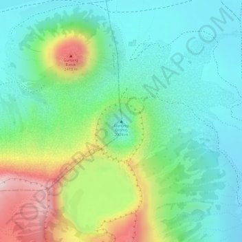
Name: Mount Bromo topographic map, elevation, terrain.

Location: Mount Bromo, Pasuruan, Indonesia (-7.94212 112.95293 -7.94202 112.95303)

Average elevation: 7,346 ft

Minimum elevation: 6,923 ft

Maximum elevation: 8,215 ft

Other topographic maps

Click on a map to view its topography, its elevation and its terrain.

Surabaya

Indonesia > East Java

Average elevation: 26 ft

Papua

Indonesia

Various other smaller mountain ranges occur both north and west of the central ranges. Except in high elevations, most areas possess a hot, humid climate throughout the year, with some seasonal variation associated with the northeast monsoon season.

Average elevation: 810 ft

Central Jakarta

Indonesia

Average elevation: 33 ft

Pulau Bali

Indonesia > Bali

Bali features a diverse topography shaped by a volcanic origin, which significantly influences its landscapes and climate. The island is dominated by a central mountain range that runs from west to east, with Mount Agung, reaching an elevation of approximately 10,308 feet, standing as the highest peak and a…

Average elevation: 400 ft

Curug Wetan

Indonesia > Banten > Tangerang Regency

Average elevation: 118 ft

East Java

Indonesia

East Java has a tropical monsoon and savanna climate at lower elevation and subtropical at higher elevation. Compared with the western part of Java Island, East Java in general has less rainfall. Average rainfall is 1,900 mm per year, with a rainy season during the 100 days. The average temperature ranges…

Average elevation: 203 ft

Special Capital Region of Jakarta

Indonesia

Jakarta lies in a low and flat alluvial plain, ranging from −2 to 91 m (−7 to 299 ft) with an average elevation of 8 m (26 ft) above sea level with historically extensive swampy areas. Some parts of the city have been constructed on reclaimed tidal flats that occur in around the area. Thirteen rivers flow…

Average elevation: 16 ft

Gresik

Indonesia > East Java

Thomas Stamford Raffles in his book, The History of Java, reveals that the name of Gresik comes from the word Giri Gisik, which means "mountain near the coast", referring to the hilly topography of the Gresik town center near the coast.

Average elevation: 46 ft

Sumatra

Indonesia

Average elevation: 223 ft

East Kalimantan

Indonesia

Average elevation: 715 ft

East Java

Indonesia

East Java has a tropical monsoon and savanna climate at lower elevation and subtropical at higher elevation. Compared with the western part of Java Island, East Java in general has less rainfall. Average rainfall is 1,900 mm per year, with a rainy season during the 100 days. The average temperature ranges…

Average elevation: 203 ft

Bekasi

Indonesia > West Java

The City of Bekasi is a part of the Bekasi river basin, located in the downstream area of the basin with slopes ranging from 0 to 2% and elevations between 11 meters to 81 meters above sea level. The city of Bekasi is part of the Bekasi river basin and is located in the downstream area of the basin, with a…

Average elevation: 105 ft

Semarang

Indonesia > Central Java

Semarang is located on the northern coast of Java. The city of Semarang is one of the important cities located on the north coast of Java and as the main hub connecting Jakarta and Surabaya, and cities in the southern interior of Java Surakarta and Yogyakarta. Semarang City has a height ranging from 2 m (6.6…

Average elevation: 351 ft

Bima

Indonesia > West Nusa Tenggara

Average elevation: 240 ft

Plumpang

Indonesia > East Java > Tuban

Average elevation: 115 ft

Central Jakarta

Indonesia

Average elevation: 33 ft

Bandung City

Indonesia > West Java

Bandung (Sundanese: ᮘᮔ᮪ᮓᮥᮀ, romanized: Bandung, Sundanese pronunciation: [ˈbandʊŋ]; /ˈbɑːndʊŋ/) is the capital city of the Indonesian province of West Java. It has a population of 2,452,943 within its city limits according to the official estimates as at mid 2021, making it the fourth most…

Average elevation: 2,723 ft

Curug Wetan

Indonesia > Banten > Tangerang Regency

Average elevation: 118 ft

Menanga

Indonesia > Bali > Rendang

Average elevation: 2,136 ft

Munjul

Indonesia > East Jakarta

Average elevation: 200 ft

Hutan Kota Munjul

Indonesia > East Jakarta > Munjul

Average elevation: 210 ft

Borneo

Indonesia

Before sea levels rose at the end of the last Ice Age, Borneo was part of the mainland of Asia, forming, with Java and Sumatra, the upland regions of a peninsula that extended east from present day Indochina. The South China Sea and Gulf of Thailand now submerge the former low-lying areas of the peninsula.…

Average elevation: 463 ft

Central Java

Indonesia

The Southern Serayu Mountains are part of the South Central Java Basin located in the southern part of the province. This mandala is a geoantiklin that extends from west to east along 100 kilometres and is divided into two parts separated by the Jatilawang valley, namely the western and eastern regions. The…

Average elevation: 272 ft

Lombok

Indonesia > West Nusa Tenggara

The island's topography is dominated by the centrally-located stratovolcano Mount Rinjani, the second-highest volcano in Indonesia, which rises to 3,726 metres (12,224 ft), making Lombok the 8th-highest island. The most recent eruption of Rinjani occurred in September 2016 at Gunung Barujari. In a 2010…

Average elevation: 630 ft

Bali

Indonesia

Bali's central mountains include several peaks over 2,000 metres (6,600 feet) in elevation and active volcanoes such as Mount Batur. The highest is Mount Agung (3,031 m, 9,944 ft), known as the "mother mountain", which is an active volcano rated as one of the world's most likely sites for a massive eruption…

Average elevation: 289 ft

Simanindo

Indonesia > North Sumatra > Samosir

Average elevation: 3,973 ft

Tunjuk

Indonesia > Bali > Tabanan

Average elevation: 915 ft

Samosir

Indonesia > North Sumatra

Average elevation: 4,016 ft

Benda Baru

Indonesia > Banten > South Tangerang

Average elevation: 187 ft

Pondok Cabe Ilir

Indonesia > Banten > South Tangerang

Average elevation: 184 ft

Sekar

Indonesia > East Java > Bojonegoro

Average elevation: 653 ft

Bali

Indonesia

Bali's central mountains include several peaks over 2,000 metres (6,600 feet) in elevation and active volcanoes such as Mount Batur. The highest is Mount Agung (3,031 m; 9,944 ft), known as the "mother mountain", which is an active volcano rated as one of the world's most likely sites for a massive eruption…

Average elevation: 289 ft

Tembalang

Indonesia > Central Java > Semarang

Average elevation: 348 ft

Jayapura

Indonesia > Papua

Average elevation: 866 ft

Kabupaten Malang

Indonesia

Average elevation: 2,156 ft

Kediri Regency

Indonesia > East Java

Average elevation: 971 ft

Wonogiri

Indonesia > Central Java

Average elevation: 1,093 ft

Juwana

Indonesia > Central Java

Average elevation: 13 ft

Pakulonan Barat

Indonesia > Banten > Tangerang Regency

Average elevation: 82 ft

Pulau Gebe

Indonesia > North Maluku > Sanafi

Average elevation: 36 ft

Lakarsantri

Indonesia > East Java > Surabaya

Average elevation: 56 ft

Aceh Barat

Indonesia > Aceh

Average elevation: 1,030 ft

Borneo

Indonesia

Before sea levels rose at the end of the last ice age, Borneo was part of the mainland of Asia, forming, with Java and Sumatra, the upland regions of a peninsula that extended east from present day Indochina. The South China Sea and Gulf of Thailand now submerge the former low-lying areas of the peninsula.…

Average elevation: 463 ft

Baureno

Indonesia > East Java > Mojokerto

Average elevation: 348 ft

Balikpapan

Indonesia > East Kalimantan

Topography of Balikpapan is generally hilly (85%), with only small areas of flat land (15%), mostly along the coast and surrounding the hilly areas. The hills are less than 100 meters (330 feet) higher than the adjacent valleys. The altitude of Balikpapan ranges from 0 to 80 meters (260 feet) above sea level.…

Average elevation: 69 ft

Sijunjung

Indonesia > West Sumatra

Average elevation: 1,404 ft

Temanggung

Indonesia > Central Java

Temanggung Regency is located on the volcanic Dieng Plateau with an average elevation between 500 and 1450 meters. It is landlocked. The volcanoes Mount Sundoro and Mount Sumbing rise on its border with the Wonosobo Regency. Its major drainage system is the Progo River and its tributaries.

Average elevation: 2,530 ft

Pecatu

Indonesia > Bali > Kuta Selatan

Pecatu is located in South Kuta District of Badung Regency. It is at the western end of the Bukit Peninsula in south Bali, and has a hilly topography with limestone cliffs isolating small, short beaches that have been privately developed. Nusa Dua, on the opposite side of the peninsula, is flat and is a…

Average elevation: 210 ft

Bandar Lampung

Indonesia > Lampung

Average elevation: 476 ft

Makassar

Indonesia > South Sulawesi

Makassar City is a city located near the coast that stretches along the western and northern corridors and is also known as the "Waterfront City" which contains several rivers such as the Tallo River, Jeneberang River, and Pampang River) all of which flow into the city. Makassar City is a stretch of lowland at…

Average elevation: 43 ft

Jayapura

Indonesia > Papua

The topography of Jayapura varies from valleys to hills, plateaus, and mountains up to 700 metres (2,300 ft) above sea level. Jayapura overlooks the Yos Sudarso Bay. Jayapura is about 83,548 hectares (206,450 acres) in land area, and is divided into five districts. Around 30% of the area is inhabited, with the…

Average elevation: 528 ft

Lhokseumawe

Indonesia > Aceh

Lhokseumawe City is located between 4˚ - 5˚ North Latitude and 96˚ - 97˚ East Longitude with an average altitude of 13 metres above sea level. Lhokseumawe was given the status of an independent city (separate from North Aceh Regency, which surrounds it on all the landward sides) based on Law Number 2 of…

Average elevation: 33 ft

Ungasan

Indonesia > Bali > Kuta Selatan

Average elevation: 417 ft

Sekaran

Indonesia > Central Java > Semarang

Average elevation: 489 ft

Java

Indonesia

Java is an island with a large amount of biodiversity. The natural environment of Java is tropical rainforest, with ecosystems ranging from coastal mangrove forest on the north coast, rocky coastal cliffs on the southern coast, and low-lying tropical forest to high altitude rainforest on the slopes of…

Average elevation: 128 ft

Lampung

Indonesia

Between 1969 and 1970, the total area of forest land in Lampung that had been used was 249,200 hectares. In 2000, there were 48 permits issued; in 1980, the number reached 76 permits. The topography of the region in the western part is mostly hilly, while the eastern part is mostly a lowland area that is…

Average elevation: 364 ft

Sawangan

Indonesia > Central Java > Batang

Average elevation: 207 ft

Pecatu

Indonesia > Bali > Kuta Selatan

Pecatu is located in South Kuta District of Badung Regency. It is at the western end of the Bukit Peninsula in south Bali, and has a hilly topography with limestone cliffs isolating small, short beaches that have been privately developed. Nusa Dua, on the opposite side of the peninsula, is flat and is a…

Average elevation: 210 ft

South Tangerang

Indonesia > Banten

Average elevation: 131 ft

Pulau Bali

Indonesia > Bali

Bali's central mountains include several peaks over 2,000 metres (6,600 feet) in elevation and active volcanoes such as Mount Batur. The highest is Mount Agung (3,031 m, 9,944 ft), known as the "mother mountain", which is an active volcano rated as one of the world's most likely sites for a massive eruption…

Average elevation: 400 ft

Java

Indonesia

Java is an island with a large amount of biodiversity. The natural environment of Java is tropical rainforest, with ecosystems ranging from coastal mangrove forest on the north coast, rocky coastal cliffs on the southern coast, and low-lying tropical forest to high altitude rainforest on the slopes of…

Average elevation: 128 ft

Sidoarjo

Indonesia > East Java

Average elevation: 197 ft

Kubu Raya

Indonesia > West Kalimantan

Average elevation: 30 ft

Cimanggu I

Indonesia > West Java > Bogor > Cibungbulang

Average elevation: 673 ft

Pondok Udik

Indonesia > West Java > Bogor > Kemang

Average elevation: 430 ft

Pantai Ayah

Indonesia > Central Java > Kebumen > Ayah

Average elevation: 220 ft

Sulawesi

Indonesia

The lowland forests on the island have mostly been removed. Because of the relative geological youth of the island and its dramatic and sharp topography, the lowland areas are naturally limited in their extent. The past decade has seen dramatic conversion of this rare and endangered habitat. The island also…

Average elevation: 322 ft

Tangerang

Indonesia > Banten

Topographically, Tangerang City is mostly located at an altitude of 10-30 meters above sea level, aka the whole area is in the lowlands. The northern part of the city (covering most of Benda District) has an average height of 10 meters above sea level, while the southern part of Tangerang City has a height of…

Average elevation: 52 ft

Semarang

Indonesia > Central Java

Semarang is located on the northern coast of Java. The city of Semarang is one of the important cities located on the north coast of Java and as the main hub connecting Jakarta and Surabaya, and cities in the southern interior of Java Surakarta and Yogyakarta. Semarang City has a height ranging from 2 m (6.6…

Average elevation: 351 ft

Kab Bekasi

Indonesia > West Java

Average elevation: 69 ft

Aceh Tamiang

Indonesia > Aceh

Average elevation: 951 ft

Ciputat Timur

Indonesia > Banten > South Tangerang

Average elevation: 138 ft

Kramat Pela

Indonesia > South Jakarta

Average elevation: 79 ft

Dangin Puri Kelod

Indonesia > Bali > Denpasar > East Denpasar

Average elevation: 66 ft

Mambal

Indonesia > Bali > Abiansemal

Average elevation: 459 ft

Yahukimo

Indonesia > Highland Papua

Yahukimo Regency is located in Highland Papua Province, Indonesia. Its geography consists mostly of mountainous areas and highlands. The regency has mountainous terrain and dense forests, with altitudes varying from lowlands to high mountains. This hilly topography makes access to some areas difficult and…

Average elevation: 4,331 ft

Pajang

Indonesia > Banten > Tangerang

Average elevation: 23 ft

Kembangan Selatan

Indonesia > West Jakarta

Average elevation: 26 ft

Krendang

Indonesia > West Jakarta

Average elevation: 20 ft

Cipondoh

Indonesia > Banten > Tangerang

Average elevation: 39 ft

Tajur

Indonesia > Banten > Tangerang

Average elevation: 69 ft

Jasem

Indonesia > Mojokerto

Average elevation: 52 ft

Pekanbaru

Indonesia > Riau

Average elevation: 79 ft

Hulu Gurung

Indonesia > West Kalimantan > Kapuas Hulu

Average elevation: 522 ft

City of Tebing Tinggi

Indonesia > North Sumatra

Average elevation: 79 ft

Gunung Putri

Indonesia > West Java > Bogor

Average elevation: 236 ft

Borneo

Indonesia

Before sea levels rose at the end of the last ice age, Borneo was part of the mainland of Asia, forming, with Java and Sumatra, the upland regions of a peninsula that extended east from present day Indochina. The South China Sea and Gulf of Thailand now submerge the former low-lying areas of the peninsula.…

Average elevation: 463 ft

Gresik

Indonesia > East Java

Thomas Stamford Raffles in his book, The History of Java, reveals that the name of Gresik comes from the word Giri Gisik, which means "mountain near the coast", referring to the hilly topography of the Gresik town center near the coast.

Average elevation: 46 ft

Puncak

Indonesia > Central Papua

Average elevation: 5,512 ft

Kendari

Indonesia > Southeast Sulawesi

Kendari borders the Konawe Regency in the north, South Konawe Regency in the south and west, and Kendari Bay in the east. The city is on the southeastern part of mainland Sulawesi island; several smaller islands around the bay are within its boundaries. The city's topography varies from flat to hilly. Coastal…

Average elevation: 220 ft

Pulau Nias

Indonesia > North Sumatra

Average elevation: 138 ft

Blitar

Indonesia > East Java

Blitar is a landlocked city in East Java, Indonesia, about 73 km from Malang and 167 km from Surabaya. The area lies within longitude 111° 40' – 112° 09' East and its latitude is 8° 06' South. The city of Blitar lies at an altitude on average 167 metres above sea level, and is an enclave within Blitar…

Average elevation: 591 ft

Gear up for your next adventure:

🔦Powerful Headlamps - Ultra-bright hands-free lighting for night navigation
🛡️Insect Repellent - Protection against bugs during outdoor activities
🖼️Topo Map Wall Art - Decorative topographic prints of famous peaks and regions
🧯Portable Fire Pit - Compact fire pit for camping spots
🥩Freeze-Dried Meals - Nutritious and lightweight food for remote expeditions

As an Amazon Associate, this site earns from qualifying purchases at no extra cost to you.