Java topographic map
Click on the map to display elevation.
Java
Java is an island with a large amount of biodiversity. The natural environment of Java is tropical rainforest, with ecosystems ranging from coastal mangrove forest on the north coast, rocky coastal cliffs on the southern coast, and low-lying tropical forest to high altitude rainforest on the slopes of mountainous volcanic regions in the interior. The Javan environment and climate gradually alters from west to east; from wet and humid dense rainforest in western parts, to a dry savanna environment in the east, corresponding to the climate and rainfall in these regions.
About this map
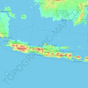
Name: Java topographic map, elevation, terrain.
Location: Java, Indonesia (-9.03014 104.65132 -4.03879 116.48418)
Average elevation: 128 ft
Minimum elevation: -7 ft
Maximum elevation: 10,000 ft
Other topographic maps
Click on a map to view its topography, its elevation and its terrain.



















Sampean
Indonesia > North Sumatra > Kabupaten Humbang Hasundutan > Dolok Sanggul
Average elevation: 4,134 ft








Selan River
Indonesia > Bangka-Belitung Islands > Bangka Tengah > Dusun Pangkal Raya
Average elevation: 43 ft


Tugu Fakultas Teknik UGM
Indonesia > Special Region of Yogyakarta > Sleman Regency > Sinduadi
Average elevation: 469 ft


Sendang Gila Waterfall
Indonesia > West Nusa Tenggara > Lombok Utara > Senaru
Average elevation: 1,886 ft








Kalingiwo
Indonesia > Special Region of Yogyakarta > Kulonprogo > Hargowilis
Average elevation: 961 ft

Kaliurang Timur
Indonesia > Special Region of Yogyakarta > Sleman Regency > Hargobinangun
Average elevation: 2,913 ft