
Make a donation
Gear up for your next adventure:
As an Amazon Associate, this site earns from qualifying purchases at no extra cost to you.
East Lyme topographic map
Click on the map to display elevation.
Make a donation
Gear up for your next adventure:
As an Amazon Associate, this site earns from qualifying purchases at no extra cost to you.
East Lyme
The topography of East Lyme consists of rolling hills and lush valleys rounded by glaciers during the last Ice Age. Hills rise to elevations of 250 to 350 feet (76 to 107 m) above sea level in the eastern and central areas of the town. The highest point in town is an unnamed hill with an elevation of 500 feet (150 m) located in Nehantic State Forest in the northwest corner of the town. East Lyme is especially scenic in the summer when the trees are in bloom. On its east and southern sides, the town abuts tidewater. The tidal Niantic River on the east feeds Niantic Bay, an arm of Long Island Sound, which forms the southern edge of the town.
Make a donation
Gear up for your next adventure:
As an Amazon Associate, this site earns from qualifying purchases at no extra cost to you.
About this map
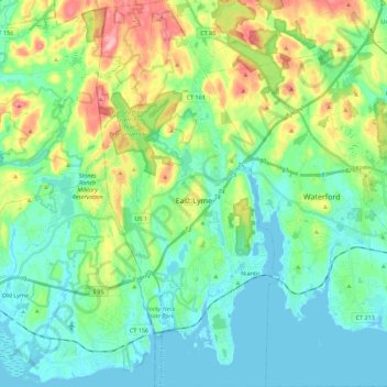
Name: East Lyme topographic map, elevation, terrain.
Average elevation: 135 ft
Minimum elevation: -10 ft
Maximum elevation: 499 ft
Make a donation
Gear up for your next adventure:
As an Amazon Associate, this site earns from qualifying purchases at no extra cost to you.
Other topographic maps
Click on a map to view its topography, its elevation and its terrain.
High Rock
United States > Connecticut > Southeastern Connecticut Planning Region > Waterford
Average elevation: 128 ft
Chesterfield
United States > Connecticut > Southeastern Connecticut Planning Region > Montville
Average elevation: 253 ft
North Franklin
United States > Connecticut > Southeastern Connecticut Planning Region
Average elevation: 338 ft
Mystic
United States > Connecticut > Southeastern Connecticut Planning Region
Average elevation: 79 ft
Make a donation
Gear up for your next adventure:
As an Amazon Associate, this site earns from qualifying purchases at no extra cost to you.
Flanders
United States > Connecticut > Southeastern Connecticut Planning Region > East Lyme
Average elevation: 141 ft
Manitock Spring
United States > Connecticut > Southeastern Connecticut Planning Region > Waterford
Average elevation: 85 ft
Quiambaug
United States > Connecticut > Southeastern Connecticut Planning Region > Mystic
Average elevation: 26 ft
Oakdale
United States > Connecticut > Southeastern Connecticut Planning Region > Montville
Average elevation: 463 ft
Make a donation
Gear up for your next adventure:
As an Amazon Associate, this site earns from qualifying purchases at no extra cost to you.
Austrailia Beach
United States > Connecticut > Southeastern Connecticut Planning Region > Mystic
Average elevation: 62 ft
Jordan Village
United States > Connecticut > Southeastern Connecticut Planning Region > Waterford
Average elevation: 89 ft
Giants Neck
United States > Connecticut > Southeastern Connecticut Planning Region > East Lyme
Average elevation: 30 ft
Pepperbox Hill
United States > Connecticut > Southeastern Connecticut Planning Region > Waterford
Average elevation: 59 ft
Make a donation
Gear up for your next adventure:
As an Amazon Associate, this site earns from qualifying purchases at no extra cost to you.
Austrailia Beach
United States > Connecticut > Southeastern Connecticut Planning Region > Mystic
Average elevation: 62 ft
Montville Center
United States > Connecticut > Southeastern Connecticut Planning Region > Montville
Average elevation: 348 ft
Four Corners
United States > Connecticut > Southeastern Connecticut Planning Region > Montville
Average elevation: 354 ft
Taftville Reservoir #1 Dam
United States > Connecticut > Southeastern Connecticut Planning Region > Norwich
Average elevation: 246 ft
Make a donation
Gear up for your next adventure:
As an Amazon Associate, this site earns from qualifying purchases at no extra cost to you.
Mystic
United States > Connecticut > Southeastern Connecticut Planning Region
Average elevation: 79 ft
Blue Lake
United States > Connecticut > Southeastern Connecticut Planning Region > North Stonington
Average elevation: 348 ft
Blackboys
United States > Connecticut > Southeastern Connecticut Planning Region > East Lyme
Average elevation: 125 ft
Quiambaug
United States > Connecticut > Southeastern Connecticut Planning Region > Mystic
Average elevation: 26 ft
Make a donation
Gear up for your next adventure:
As an Amazon Associate, this site earns from qualifying purchases at no extra cost to you.
Quaker Hill
United States > Connecticut > Southeastern Connecticut Planning Region > Waterford
Average elevation: 115 ft
Center Groton
United States > Connecticut > Southeastern Connecticut Planning Region > Groton
Average elevation: 161 ft
Uncasville
United States > Connecticut > Southeastern Connecticut Planning Region > Montville
Average elevation: 131 ft
Chesterfield
United States > Connecticut > Southeastern Connecticut Planning Region > Montville
Average elevation: 253 ft
Make a donation
Gear up for your next adventure:
As an Amazon Associate, this site earns from qualifying purchases at no extra cost to you.
Austrailia Beach
United States > Connecticut > Southeastern Connecticut Planning Region > Mystic
Average elevation: 62 ft
Flanders
United States > Connecticut > Southeastern Connecticut Planning Region > East Lyme
Average elevation: 141 ft
Huntley Island
United States > Connecticut > Southeastern Connecticut Planning Region > East Lyme
Average elevation: 23 ft
Austrailia Beach
United States > Connecticut > Southeastern Connecticut Planning Region > Mystic
Average elevation: 62 ft
Make a donation
Gear up for your next adventure:
As an Amazon Associate, this site earns from qualifying purchases at no extra cost to you.
Hanover Reservoir
United States > Connecticut > Southeastern Connecticut Planning Region > Hanover
Average elevation: 299 ft
North Stonington
United States > Connecticut > Southeastern Connecticut Planning Region
Average elevation: 240 ft
Mystic
United States > Connecticut > Southeastern Connecticut Planning Region > Stonington
Average elevation: 56 ft
Avery Hill
United States > Connecticut > Southeastern Connecticut Planning Region > Ledyard
Average elevation: 171 ft
Make a donation
Gear up for your next adventure:
As an Amazon Associate, this site earns from qualifying purchases at no extra cost to you.
Fitch Corner
United States > Connecticut > Southeastern Connecticut Planning Region > Montville
Average elevation: 167 ft
Seal Rocks
United States > Connecticut > Southeastern Connecticut Planning Region > Stonington
Average elevation: 121 ft