
Make a donation
Gear up for your next adventure:
As an Amazon Associate, this site earns from qualifying purchases at no extra cost to you.
Lake Lanao topographic map
Click on the map to display elevation.
Make a donation
Gear up for your next adventure:
As an Amazon Associate, this site earns from qualifying purchases at no extra cost to you.
Lake Lanao
The lake has great hydroelectric potential due to its 700 meter elevation, and as such, in 1950, the Philippines National Power Corporation (NAPOCOR) began the construction of a series of hydroelectric plants titled Agus I – Agus VII along the Agus River system, which generates 70% of the electricity used by the people of Mindanao. In 1978, the Marawi Lake Regulation Dam (MLRD) was constructed at the mouth of the Agus, and five power plants were commissioned shortly afterwards (Agus I, II, IV, V, and VII). Notably, Agus I is not located on the river, but directly on the shoreline of the lake, in the heart of Marawi City. While the MLRD does not affect the function of the four downstream dams, the construction of Agus I effectively turned the lake into a reservoir, sparking significant backlash among the Maranao. In October 1990, the Maranao publicly demonstrated as Agus I was finishing construction, leading to the birth of the Save Lake Lanao Movement (SALAM), which intended to obstruct NAPOCOR's progress in building Agus I. SALAM contended that the dam would act as an artificial, alternative outlet to the Agus that is deeply unnatural and would result in a 9 meter fluctuation of the lake level. Conflict between SALAM and NAPOCOR resulted in the creation of the Task Force on Agus 1 by Aquilino Pimentel Jr., which subsequently delayed the commission date of the plant to January 14, 1992. In the two months following Agus I's operation date, President Corazon Aquino declared the Lake Lanao watershed as a reservation and established the Lake Lanao Watershed Protection and Development Council (LLWPDC), a policy group with both SALAM and NAPOCOR representatives. Despite these efforts, NAPOCOR has since not made any major concessions to the Maranao. SALAM and the Maranao continue to protect the Lanao watershed from environmental degradation.
Make a donation
Gear up for your next adventure:
As an Amazon Associate, this site earns from qualifying purchases at no extra cost to you.
About this map
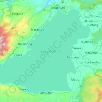
Name: Lake Lanao topographic map, elevation, terrain.
Location: Lake Lanao, Lanao del Sur, Bangsamoro, Philippines (7.78083 124.10453 8.00328 124.37106)
Average elevation: 2,582 ft
Minimum elevation: 2,014 ft
Maximum elevation: 5,899 ft
Make a donation
Gear up for your next adventure:
As an Amazon Associate, this site earns from qualifying purchases at no extra cost to you.
Other topographic maps
Click on a map to view its topography, its elevation and its terrain.
Marawi City
Marawi is located upon the shores of Lake Lanao. It is primarily inhabited by the Maranao people. The city is also called the "Summer Capital of the South" due to its higher elevation and cooler climate, a nickname it shares with Malaybalay.
Average elevation: 2,320 ft
Mount Piapayungan
Mount Ragang, also called Mount Piapayungan and Blue Mountain by the local people, is an active stratovolcano on Mindanao island in the Philippines. With an elevation of 2,815 metres (9,236 ft), it is the seventh highest mountain in the Philippines and the highest point in the Lanao del Sur province.
Average elevation: 7,854 ft
Make a donation
Gear up for your next adventure:
As an Amazon Associate, this site earns from qualifying purchases at no extra cost to you.
Bayang
The topography of the municipality is generally characterized by moderately sloping lands. Approximately 2,606 hectares (63.45%) have moderate slopes of 8 – 15%. Steep lands with a slope 40 – 60% comprise 20.14% (827) ha. About 674 (16.41) have nearly level terrain.
Average elevation: 2,566 ft
Make a donation
Gear up for your next adventure:
As an Amazon Associate, this site earns from qualifying purchases at no extra cost to you.
Marawi City
Marawi is located upon the shores of Lake Lanao. It is primarily inhabited by the Maranao people. The city is also called the "Summer Capital of the South" due to its higher elevation and cooler climate, a nickname it shares with Malaybalay.
Average elevation: 2,320 ft
Make a donation
Gear up for your next adventure:
As an Amazon Associate, this site earns from qualifying purchases at no extra cost to you.
Make a donation
Gear up for your next adventure:
As an Amazon Associate, this site earns from qualifying purchases at no extra cost to you.
Make a donation
Gear up for your next adventure:
As an Amazon Associate, this site earns from qualifying purchases at no extra cost to you.
Wao
There are three possible etymology for the name of the municipality Wao. One is a local folklore which involved Bai Sa Raya, a Moro princess from a monarchy in Cotabato who coincidentally visited the area which is now known as "Wao" during a serious drought. This led to the place being called Wao from the word…
Average elevation: 1,959 ft
Make a donation
Gear up for your next adventure:
As an Amazon Associate, this site earns from qualifying purchases at no extra cost to you.
Makaturing
Mount Makaturing, also known locally as Palaw a Magatoring, is a stratovolcano on Mindanao island in the Philippines. It is located in the province of Lanao del Sur (particularly in the town of Butig) in the Bangsamoro Autonomous Region in Muslim Mindanao. Makaturing has an elevation of 1,940 metres (6,365 ft)…
Average elevation: 5,102 ft
Make a donation
Gear up for your next adventure:
As an Amazon Associate, this site earns from qualifying purchases at no extra cost to you.
Wao
There are three possible etymology for the name of the municipality Wao. One is a local folklore which involved Bai Sa Raya, a Moro princess from a monarchy in Cotawato visited the area which is now known as "Wao" coincidentally during a serious drought. This led to the place to being called Wao from the word…
Average elevation: 1,959 ft
Make a donation
Gear up for your next adventure:
As an Amazon Associate, this site earns from qualifying purchases at no extra cost to you.
Marawi
Marawi is located upon the shores of Lake Lanao.[6] It is primarily inhabited by the Maranao people. The city is also called the "summer capital of the south" due to its higher elevation and cooler climate,[7] a nickname it shares with Malaybalay.[8][better source needed]
Average elevation: 2,320 ft
Make a donation
Gear up for your next adventure:
As an Amazon Associate, this site earns from qualifying purchases at no extra cost to you.
Amai Manabilang
Mountain ranges, hills, plateaus, and flatland characterize the topography of the barangay. It has a vast agricultural land suited for crops like rice, corn, carrots, sugar cane. Its hydrological features comprise rivers like the Maridugao and Sumogot, streams, swamps, creeks and springs.
Average elevation: 3,173 ft