
Tsageri Municipality topographic map
Interactive map
Click on the map to display elevation.
About this map
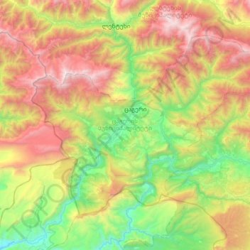
Name: Tsageri Municipality topographic map, elevation, terrain.
Average elevation: 4,278 ft
Minimum elevation: 620 ft
Maximum elevation: 10,374 ft
Other topographic maps
Click on a map to view its topography, its elevation and its terrain.
Shovi
Georgia > Racha-Lechkhumi and Lower Svaneti > Oni Municipality
Shovi, Oni Municipality, Racha-Lechkhumi and Lower Svaneti, Georgia
Average elevation: 5,879 ft
Oni, Georgia
Georgia > Racha-Lechkhumi and Lower Svaneti
Oni, Georgia, Racha-Lechkhumi and Lower Svaneti, Georgia
Average elevation: 6,965 ft
Ambrolauri
Georgia > Racha-Lechkhumi and Lower Svaneti > Ambrolauri Municipality
Ambrolauri, Ambrolauri Municipality, Racha-Lechkhumi and Lower Svaneti, Georgia
Average elevation: 2,047 ft
Mami
Georgia > Racha-Lechkhumi and Lower Svaneti > Lentekhi Municipality
Mami, Lentekhi Municipality, Racha-Lechkhumi and Lower Svaneti, Georgia
Average elevation: 4,649 ft
Oni
Georgia > Racha-Lechkhumi and Lower Svaneti > Oni, Georgia > Oni
Oni, Oni, Georgia, Racha-Lechkhumi and Lower Svaneti, Georgia
Average elevation: 3,123 ft