
Durach topographic map
Interactive map
Click on the map to display elevation.
Durach
Die Höhenlage reicht von 684 m ü. NHN an der Mündung der Durach in die Iller bis 964 m ü. NHN bei Bodelsberg.
About this map
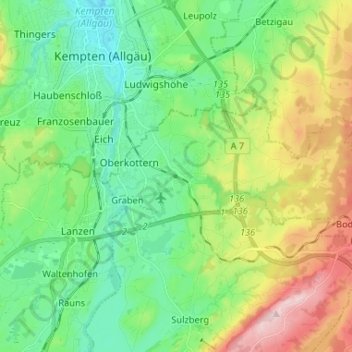
Name: Durach topographic map, elevation, terrain.
Location: Durach, Landkreis Oberallgäu, Bayern, 87471, Deutschland (47.67845 10.31885 47.71454 10.44947)
Average elevation: 2,487 ft
Minimum elevation: 2,156 ft
Maximum elevation: 3,196 ft
Other topographic maps
Click on a map to view its topography, its elevation and its terrain.
Steibis
Deutschland > Bayern > Landkreis Oberallgäu > Oberstaufen > Steibis
Steibis (allgäuerisch Schteibing) ist ein Ortsteil in der Gemarkung Aach im Allgäu des Marktes Oberstaufen im bayerisch-schwäbischen Landkreis Oberallgäu. Es liegt auf einer leicht abfallenden Hochebene zwischen dem nördlichen Weissachtal und der südlich liegenden Hochgratkette auf einer Höhe von 860 m.…
Average elevation: 2,867 ft