
Make a donation
Gear up for your next adventure:
As an Amazon Associate, this site earns from qualifying purchases at no extra cost to you.
Tuxedo topographic map
Click on the map to display elevation.
Make a donation
Gear up for your next adventure:
As an Amazon Associate, this site earns from qualifying purchases at no extra cost to you.
About this map
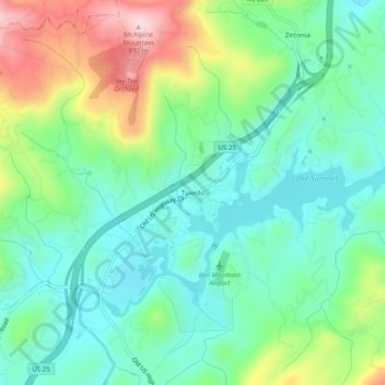
Name: Tuxedo topographic map, elevation, terrain.
Average elevation: 2,267 ft
Minimum elevation: 1,962 ft
Maximum elevation: 2,943 ft
Henderson County trails, hiking, mountain biking, running and outdoor activities
Make a donation
Gear up for your next adventure:
As an Amazon Associate, this site earns from qualifying purchases at no extra cost to you.
Other topographic maps
Click on a map to view its topography, its elevation and its terrain.
Make a donation
Gear up for your next adventure:
As an Amazon Associate, this site earns from qualifying purchases at no extra cost to you.
Etowah
United States > North Carolina > Henderson County
Etowah has an altitude of 2,101 feet (640 m).
Average elevation: 2,139 ft
Hendersonville Reservoir
United States > North Carolina > Henderson County
Average elevation: 2,805 ft
Make a donation
Gear up for your next adventure:
As an Amazon Associate, this site earns from qualifying purchases at no extra cost to you.
Mills River
United States > North Carolina > Henderson County > Mills River
Average elevation: 2,251 ft
Make a donation
Gear up for your next adventure:
As an Amazon Associate, this site earns from qualifying purchases at no extra cost to you.
Mills River
United States > North Carolina > Henderson County > Mills River > Oak Hill Court
Average elevation: 2,113 ft
Make a donation
Gear up for your next adventure:
As an Amazon Associate, this site earns from qualifying purchases at no extra cost to you.