
Make a donation
Gear up for your next adventure:
As an Amazon Associate, this site earns from qualifying purchases at no extra cost to you.
Saint-Marc topographic map
Click on the map to display elevation.
Make a donation
Gear up for your next adventure:
As an Amazon Associate, this site earns from qualifying purchases at no extra cost to you.
About this map
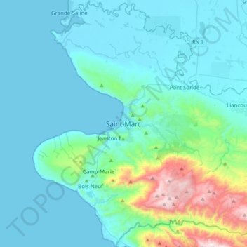
Name: Saint-Marc topographic map, elevation, terrain.
Average elevation: 597 ft
Minimum elevation: 0 ft
Maximum elevation: 4,429 ft
Make a donation
Gear up for your next adventure:
As an Amazon Associate, this site earns from qualifying purchases at no extra cost to you.
Other topographic maps
Click on a map to view its topography, its elevation and its terrain.
3e Rivière Blanche
Haiti > Artibonite Department > Arrondissement Gros Morne
Average elevation: 1,368 ft
Make a donation
Gear up for your next adventure:
As an Amazon Associate, this site earns from qualifying purchases at no extra cost to you.
2e Sources Chaudes
Haiti > Artibonite Department > Arrondissement Gros Morne
Average elevation: 466 ft
Make a donation
Gear up for your next adventure:
As an Amazon Associate, this site earns from qualifying purchases at no extra cost to you.
6e Savane Carrée
Haiti > Artibonite Department > Arrondissement Gros Morne
Average elevation: 1,033 ft
Make a donation
Gear up for your next adventure:
As an Amazon Associate, this site earns from qualifying purchases at no extra cost to you.
4ème Savane à Roche
Haiti > Artibonite Department > Commune Petite Rivière de l'Artibonite
Average elevation: 1,519 ft
3e Labady
Haiti > Artibonite Department > Commune Petite Rivière de l'Artibonite
Average elevation: 410 ft
Make a donation
Gear up for your next adventure:
As an Amazon Associate, this site earns from qualifying purchases at no extra cost to you.