
Make a donation
Gear up for your next adventure:
As an Amazon Associate, this site earns from qualifying purchases at no extra cost to you.
Mount Augusta topographic map
Click on the map to display elevation.
Make a donation
Gear up for your next adventure:
As an Amazon Associate, this site earns from qualifying purchases at no extra cost to you.
About this map
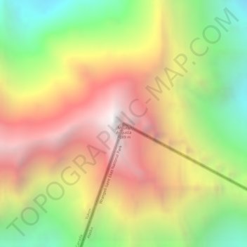
Name: Mount Augusta topographic map, elevation, terrain.
Location: Mount Augusta, Yakutat, Alaska, United States (60.30803 -140.45826 60.30813 -140.45816)
Average elevation: 10,827 ft
Minimum elevation: 7,684 ft
Maximum elevation: 13,927 ft
Make a donation
Gear up for your next adventure:
As an Amazon Associate, this site earns from qualifying purchases at no extra cost to you.
Other topographic maps
Click on a map to view its topography, its elevation and its terrain.
Hubbard Glacier
United States > Alaska > Yakutat
The longest source for Hubbard Glacier originates 122 kilometres (76 mi) from its snout and is located at about 61°00′N 140°09′W / 61.000°N 140.150°W / 61.000; -140.150, approximately 8 kilometres (5 mi) west of Mount Walsh with an elevation around 3,400 metres (11,200 ft). A shorter tributary…
Average elevation: 6,207 ft
Malaspina Glacier
United States > Alaska > Yakutat
The Malaspina is up to 600 meters (2,000 ft) thick in places, with the elevation of its bottom being estimated to be as much as 300 m (980 ft) below sea level. There are two lakes on its margins: Oily Lake to the northwest, at the foot of the Samovar Hills between the Agassiz and Seward glaciers, and Malaspina…
Average elevation: 1,289 ft
Make a donation
Gear up for your next adventure:
As an Amazon Associate, this site earns from qualifying purchases at no extra cost to you.
Hubbard Glacier
United States > Alaska > Yakutat
The longest source for Hubbard Glacier originates 122 kilometres (76 mi) from its snout and is located at about 61°00′N 140°09′W / 61.000°N 140.150°W / 61.000; -140.150, approximately 8 kilometres (5 mi) west of Mount Walsh with an elevation around 3,400 metres (11,200 ft). A shorter tributary…
Average elevation: 6,207 ft
Malaspina Glacier
United States > Alaska > Yakutat
The Malaspina is up to 600 meters (2,000 ft) thick in places, with the elevation of its bottom being estimated to be as much as 300 m (980 ft) below sea level. There are two lakes on its margins: Oily Lake to the northwest, at the foot of the Samovar Hills between the Agassiz and Seward glaciers, and Malaspina…
Average elevation: 1,289 ft