
Chandolin topographic map
Interactive map
Click on the map to display elevation.
About this map
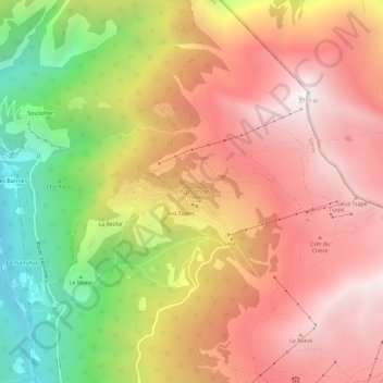
Name: Chandolin topographic map, elevation, terrain.
Location: Chandolin, Anniviers, Sierre, Valais, 3961, Suisse (46.23258 7.57867 46.27258 7.61867)
Average elevation: 6,237 ft
Minimum elevation: 2,654 ft
Maximum elevation: 8,875 ft
Other topographic maps
Click on a map to view its topography, its elevation and its terrain.
Barrage de Moiry
Suisse > Valais > Sierre > Anniviers
Barrage de Moiry, Anniviers, Sierre, Valais, 3961, Suisse
Average elevation: 8,163 ft
Cabane du Mountet CAS
Suisse > Valais > Sierre > Anniviers
Cabane du Mountet CAS, Arbengrat, Anniviers, Sierre, Valais, 3961, Suisse
Average elevation: 9,596 ft
Ober Gabelhorn
Suisse > Valais > Sierre > Anniviers
Ober Gabelhorn, Anniviers, Sierre, Valais, 3961, Suisse
Average elevation: 10,906 ft