Geolocate

Arrochar topographic map

Click on the map to display elevation.

About this map

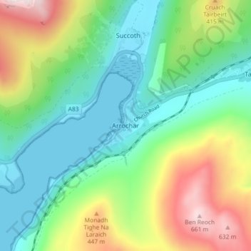
Name: Arrochar topographic map, elevation, terrain.

Location: Arrochar, Argyll and Bute, Scotland, G83 7AD, United Kingdom (56.17547 -4.76807 56.21547 -4.72807)

Average elevation: 712 ft

Minimum elevation: -3 ft

Maximum elevation: 2,228 ft

Other topographic maps

Click on a map to view its topography, its elevation and its terrain.

Tarbert

United Kingdom > Scotland > Argyll and Bute

Average elevation: 226 ft

Easdale

United Kingdom > Scotland > Argyll and Bute > Easdale

Average elevation: 26 ft

Torsa

United Kingdom > Scotland > Argyll and Bute > Cuan > Silver Moon

Average elevation: 39 ft

Texa

United Kingdom > Scotland > Argyll and Bute

Average elevation: 3 ft

Bute

United Kingdom > Scotland > Argyll and Bute > Townhead

Average elevation: 135 ft

Scarba

United Kingdom > Scotland > Argyll and Bute

Average elevation: 299 ft

Coll

United Kingdom > Scotland > Argyll and Bute > Arinagour

Average elevation: 23 ft

Ardrishaig

United Kingdom > Scotland > Argyll and Bute

Average elevation: 217 ft

Gear up for your next adventure:

📱Solar Portable Charger - Solar power bank for charging devices off‑grid
Backpacking Tent - Lightweight and durable tent for multi‑day hikes
🗺️Topographic Maps - Detailed topo maps for hiking, exploring and outdoor navigation
🛡️Insect Repellent - Protection against bugs during outdoor activities
🧥Men's Rain Shells - Premium waterproof and breathable jackets for mountain weather

As an Amazon Associate, this site earns from qualifying purchases at no extra cost to you.