
Make a donation
Gear up for your next adventure:
As an Amazon Associate, this site earns from qualifying purchases at no extra cost to you.
Lehighton topographic map
Click on the map to display elevation.
Make a donation
Gear up for your next adventure:
As an Amazon Associate, this site earns from qualifying purchases at no extra cost to you.
Lehighton
Lehighton is located in southern Carbon County at 40°49′55″N 75°42′53″W / 40.83194°N 75.71472°W / 40.83194; -75.71472 (40.831932, -75.714701). It is in northeast Pennsylvania 117 miles (188 km) west of New York City and 37 miles (60 km) south of Wilkes-Barre. The borough is situated on the west bank of the Lehigh River at an elevation ranging from 470 feet (140 m) above sea level at the river up to 725 feet (221 m) near the northwest part of town by Mahoning Township border.
Make a donation
Gear up for your next adventure:
As an Amazon Associate, this site earns from qualifying purchases at no extra cost to you.
About this map
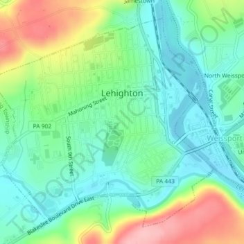
Name: Lehighton topographic map, elevation, terrain.
Location: Lehighton, Carbon County, Pennsylvania, 18235, United States (40.81949 -75.73210 40.84271 -75.70007)
Average elevation: 597 ft
Minimum elevation: 443 ft
Maximum elevation: 909 ft
Carbon County trails, hiking, mountain biking, running and outdoor activities
Make a donation
Gear up for your next adventure:
As an Amazon Associate, this site earns from qualifying purchases at no extra cost to you.
Other topographic maps
Click on a map to view its topography, its elevation and its terrain.
Albrightsville
United States > Pennsylvania > Carbon County > Kidder Township
Average elevation: 1,634 ft
Holiday Poconos
United States > Pennsylvania > Carbon County > Kidder Township
Average elevation: 1,703 ft
Make a donation
Gear up for your next adventure:
As an Amazon Associate, this site earns from qualifying purchases at no extra cost to you.
Lake Harmony
United States > Pennsylvania > Carbon County > Kidder Township > Lake Harmony
Average elevation: 1,864 ft
Hickory Run State Park
United States > Pennsylvania > Carbon County > Kidder Township
Average elevation: 1,545 ft
Lake Harmony
United States > Pennsylvania > Carbon County > Kidder Township > Lake Harmony
Average elevation: 1,808 ft
Make a donation
Gear up for your next adventure:
As an Amazon Associate, this site earns from qualifying purchases at no extra cost to you.
Beltzville State Park - Parking Lot B
United States > Pennsylvania > Carbon County > Lehighton
Average elevation: 728 ft
Holiday Poconos
United States > Pennsylvania > Carbon County > Kidder Township
Average elevation: 1,703 ft
Make a donation
Gear up for your next adventure:
As an Amazon Associate, this site earns from qualifying purchases at no extra cost to you.
Albrightsville
United States > Pennsylvania > Carbon County > Kidder Township
Average elevation: 1,634 ft
Holiday Poconos
United States > Pennsylvania > Carbon County > Kidder Township
Average elevation: 1,703 ft
Germans
United States > Pennsylvania > Carbon County > East Penn Township > Germans
Average elevation: 781 ft