Geolocate

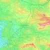
Occitania topographic map

Click on the map to display elevation.

About this map
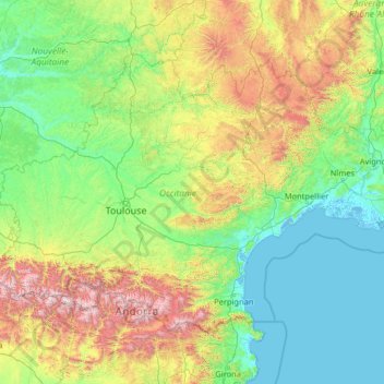
Name: Occitania topographic map, elevation, terrain.

Location: Occitania, Metropolitan France, France (42.33276 -0.32726 45.04664 4.84553)

Average elevation: 1,532 ft

Minimum elevation: -10 ft

Maximum elevation: 10,535 ft

Other topographic maps

Click on a map to view its topography, its elevation and its terrain.

Sauve-Clare

France > Provence-Alpes-Côte d'Azur > Var > Flayosc

Average elevation: 823 ft

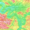
Paris

France > Paris > Paris

Paris in its early history had only the rivers Seine and Bièvre for water. From 1809, the Canal de l'Ourcq provided Paris with water from less-polluted rivers to the north-east of the capital. From 1857, the civil engineer Eugène Belgrand, under Napoleon III, oversaw the construction of a series of new…

Average elevation: 246 ft

La Fontaine

France > Normandy > Calvados > Valdallière > Le Theil-Bocage

Average elevation: 666 ft

Chartes

France > Bourgogne – Franche-Comté > Nièvre > Mhère

Average elevation: 1,348 ft

Paris Basin

France > Ile-de-France > Essonne > Bièvres

The landscape is one of very broad valleys (flood plains), modest watershed hills and well-drained plateaux of comparatively little altitude. In the south-east and east the plain of Champagne and the Seuil de Bourgogne (Threshold of Burgundy) differential erosion of the strata has left low scarps with the dip…

Average elevation: 413 ft

Pyrenees

France > Occitania > Oô

In the Western Pyrenees, from the Basque mountains near the Bay of Biscay of the Atlantic Ocean, the average elevation gradually increases from west to east.

Average elevation: 8,911 ft

La Tuile

France > Auvergne-Rhône-Alpes > Ain > Marlieux

Average elevation: 892 ft

Mont Blanc / Monte Bianco

France > Auvergne-Rhône-Alpes > Upper Savoy > Saint-Gervais-les-Bains

The climate is cold and temperate (Köppen climate classification Cfb), and is greatly influenced by altitude. Being the highest part of the Alps, Mont Blanc and surrounding mountains can create their own weather patterns. Temperatures drop as the mountains gain in height, and the summit of Mont Blanc is a…

Average elevation: 13,425 ft

Rivelin

France > Auvergne-Rhône-Alpes > Ain > Fareins

Average elevation: 640 ft

Quater

France > Great East > Moselle > Réding

Average elevation: 928 ft

L'Ange Bergère

France > Pays de la Loire > Vendée > Les Herbiers

Average elevation: 659 ft

Katiu

France > French Polynesia

Average elevation: 0 ft

Marry

France > Nouvelle-Aquitaine > Lot-et-Garonne > Veyries > Saint-Gény

Average elevation: 417 ft

Os

France > New Aquitaine > Os

Average elevation: 344 ft

Le Hangar

France > Réunion > Saint-Paul > Bois de Nèfles

Average elevation: 820 ft

Pendruc

France > Brittany > Finistère > Lambell

Average elevation: 23 ft

Bressy

France > Auvergne-Rhône-Alpes > Ain > Meximieux

Average elevation: 823 ft

La Ville Cué

France > Brittany > Morbihan > Augan

Average elevation: 272 ft

Rostomic Vihan

France > Brittany > Finistère > Châteaulin

Average elevation: 223 ft

Belle Étoile

France > Martinique > Sainte-Marie

Average elevation: 141 ft

Le Lac

France > Auvergne-Rhône-Alpes > Upper Savoy > Montriond

Average elevation: 4,898 ft

La Corderie

France > Brittany > Ille-et-Vilaine > Cherrueix

Average elevation: 7 ft

Béguey

France > Nouvelle-Aquitaine > Gironde > Salles

Average elevation: 92 ft

Les Marlots

France > Bourgogne – Franche-Comté > Nièvre > Bouhy

Average elevation: 768 ft

Fangataufa

France > French Polynesia > Tureia

Average elevation: 0 ft

Logerie

France > Nouvelle-Aquitaine > Vienne > Bonneuil-Matours

Average elevation: 384 ft

Le Haut des Caves

France > Centre-Val de Loire > Loiret > Briare

Average elevation: 489 ft

Chauffours

France > Guadeloupe > Les Abymes

Average elevation: 56 ft

Kabylie

France > Pays de la Loire > Mayenne > Voutré > Beau Soleil

Average elevation: 673 ft

Rimmel

France > Grand Est > Haut-Rhin > Katzenthal

Average elevation: 1,010 ft

Kerharo

France > Brittany > Finistère > Douarnenez > Pouldavid

Average elevation: 115 ft

Tacy

France > Guadeloupe > Capesterre-de-Marie-Galante

Average elevation: 377 ft

éboulements

France > French Polynesia > Windward Islands > Māhina > Mahina

Average elevation: 180 ft

Vincourt

France > Ile-de-France > Val-d'Oise > Jouy-le-Moutier

Average elevation: 184 ft

Cahire

France > Brittany > Morbihan > Le Hallate

Average elevation: 102 ft

Le Metayer

France > Nouvelle-Aquitaine > Haute-Vienne > Saint-Paul

Average elevation: 1,155 ft

Viard

France > Guadeloupe > Petit-Bourg

Average elevation: 105 ft

Pech d'Aspe

France > Occitania > Aude > Mas-des-Cours

Average elevation: 1,145 ft

Atha

France > Loyalty Islands Province > Maré > La Roche

Average elevation: 125 ft

Les Epinoux

France > Bourgogne – Franche-Comté > Jura > Rotalier

Average elevation: 1,047 ft

Le Tourmalet

France > Occitania > Gers > Saint-Pierre-d'Aubézies

Average elevation: 568 ft

La Ville Joubard

France > Brittany > Morbihan > Guillac

Average elevation: 223 ft

Les Houards

France > Centre-Val de Loire > Cher > Le Grouzeau

Average elevation: 515 ft

Les Turiers

France > Auvergne-Rhône-Alpes > Allier > Beaulon

Average elevation: 791 ft

Hameau de Villaré

France > Ile-de-France > Seine-et-Marne > Citry

Average elevation: 390 ft

Le Château

France > Centre-Val de Loire > Loir-et-Cher > Chambord

Average elevation: 292 ft

Vahitahi

France > French Polynesia > Nukutavake

Average elevation: 0 ft

Hasera

France > Nouvelle-Aquitaine > Gironde > Audenge

Average elevation: 3 ft

Pouyol

France > Nouvelle-Aquitaine > Haute-Vienne > Janailhac

Average elevation: 1,230 ft

le Petit Roussilon

France > Auvergne-Rhône-Alpes > Isère > Siévoz

Average elevation: 2,864 ft

Le Fragne

France > Centre-Val de Loire > Indre > Sarzay

Average elevation: 735 ft

Champvert

France > Guadeloupe > Sainte-Anne

Average elevation: 184 ft

Hellhof

France > Grand Est > Haut-Rhin > Saint-Louis

Average elevation: 846 ft

Boucan-Canot

France > Réunion > Saint-Paul

Average elevation: 135 ft

Ravine-Glissante

France > Réunion > Sainte-Rose

Average elevation: 285 ft

Fountain of the Rivers

France > Ile-de-France > Paris

Average elevation: 154 ft

Capo al Berdato

France > Corsica > Upper Corsica > Lozzi

Average elevation: 6,923 ft

Trébé

France > Brittany > Finistère > Plomelin

Average elevation: 138 ft

La Tapie

France > Occitania > Aveyron > La Salvetat-Peyralès

Average elevation: 1,608 ft

La Rosière

France > Grand Est > Vosges > La Chapelle-devant-Bruyères

Average elevation: 1,657 ft

Milieu

France > Auvergne-Rhône-Alpes > Isère > Monsteroux-Milieu

Average elevation: 1,161 ft

Gear up for your next adventure:

🔪Outdoor Multitools - Essential survival tools for gear repair and field use
📦Dry Bags Set - Waterproof storage for electronics and clothes
🛡️Insect Repellent - Protection against bugs during outdoor activities
😴Insulated Sleeping Pads - Compact and warm pads for high-elevation camping
🚑Emergency Bivvies - Heat-reflective sleeping bags for survival situations

As an Amazon Associate, this site earns from qualifying purchases at no extra cost to you.