
Moeche topographic map
Interactive map
Click on the map to display elevation.
About this map
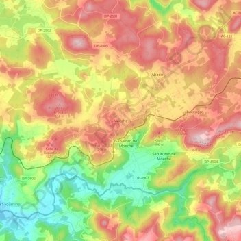
Name: Moeche topographic map, elevation, terrain.
Location: Moeche, Ferrol, La Coruña, Galicia, España (43.52297 -8.03637 43.60090 -7.91611)
Average elevation: 676 ft
Minimum elevation: 102 ft
Maximum elevation: 1,184 ft
Other topographic maps
Click on a map to view its topography, its elevation and its terrain.
Bouzamaior
España > Galicia > Ferrol > San Sadurniño
Bouzamaior, Igrexafeita, San Sadurniño, Ferrol, La Coruña, Galicia, 15324, España
Average elevation: 1,181 ft
Vila Xorxe
España > Galicia > Ferrol > Ferrol
Vila Xorxe, Serantes, Ferrol, La Coruña, Galicia, 15400, España
Average elevation: 276 ft
Santiago Apóstolo de Xubia
España > Galicia > Ferrol > Narón
Santiago Apóstolo de Xubia, Narón, Ferrol, La Coruña, Galicia, España
Average elevation: 62 ft
Muchiqueira
España > Galicia > Ferrol > Neda
Muchiqueira, Santa María de Neda, Neda, Ferrol, La Coruña, Galicia, 15510, España
Average elevation: 217 ft
Santa María de Neda
España > Galicia > Ferrol > Neda
Santa María de Neda, Neda, Ferrol, La Coruña, Galicia, España
Average elevation: 262 ft
O Carreiro
España > Galicia > Ferrol > Neda
O Carreiro, Santa María de Neda, Neda, Ferrol, La Coruña, Galicia, 15510, España
Average elevation: 194 ft
San Pedro
España > Galicia > Ferrol > As Somozas
San Pedro, Recemel, As Somozas, Ferrol, La Coruña, Galicia, 15568, España
Average elevation: 1,312 ft
Igrexafeita
España > Galicia > Ferrol > San Sadurniño
Igrexafeita, San Sadurniño, Ferrol, La Coruña, Galicia, España
Average elevation: 1,145 ft
As Somozas
As Somozas, Ferrol, La Coruña, Galicia, España
Average elevation: 1,070 ft