
Central topographic map
Click on the map to display elevation.
About this map
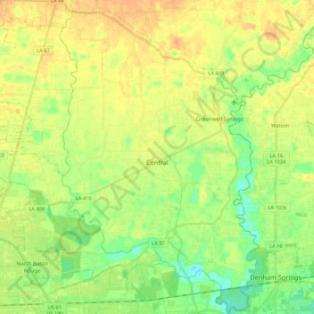
Name: Central topographic map, elevation, terrain.
Location: Central, East Baton Rouge Parish, Louisiana, United States (30.46521 -91.10327 30.64894 -90.96773)
Average elevation: 66 ft
Minimum elevation: 13 ft
Maximum elevation: 112 ft
East Baton Rouge Parish trails, hiking, mountain biking, running and outdoor activities
Other topographic maps
Click on a map to view its topography, its elevation and its terrain.
Nicholson Estates
United States > Louisiana > East Baton Rouge Parish > Baton Rouge
Average elevation: 36 ft
Campus Lake
United States > Louisiana > East Baton Rouge Parish > Baton Rouge
Average elevation: 36 ft
Delmont Place
United States > Louisiana > East Baton Rouge Parish > Baton Rouge
Average elevation: 66 ft
Goodwood Estates
United States > Louisiana > East Baton Rouge Parish > Baton Rouge
Average elevation: 56 ft
Sherwood Forest
United States > Louisiana > East Baton Rouge Parish > Baton Rouge
Average elevation: 52 ft
Magnolia Heights
United States > Louisiana > East Baton Rouge Parish > Baton Rouge
Average elevation: 36 ft
Carmen Terrace
United States > Louisiana > East Baton Rouge Parish > Baton Rouge
Average elevation: 52 ft
Bell Fontaine
United States > Louisiana > East Baton Rouge Parish > Baton Rouge
Average elevation: 52 ft
Marwede Place
United States > Louisiana > East Baton Rouge Parish > Baton Rouge
Average elevation: 56 ft