
Make a donation
Gear up for your next adventure:
As an Amazon Associate, this site earns from qualifying purchases at no extra cost to you.
Cowpens topographic map
Click on the map to display elevation.
Make a donation
Gear up for your next adventure:
As an Amazon Associate, this site earns from qualifying purchases at no extra cost to you.
About this map
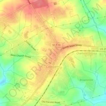
Name: Cowpens topographic map, elevation, terrain.
Location: Cowpens, Spartanburg County, South Carolina, United States (35.00595 -81.82141 35.03504 -81.78888)
Average elevation: 814 ft
Minimum elevation: 686 ft
Maximum elevation: 915 ft
Spartanburg County trails, hiking, mountain biking, running and outdoor activities
Make a donation
Gear up for your next adventure:
As an Amazon Associate, this site earns from qualifying purchases at no extra cost to you.
Other topographic maps
Click on a map to view its topography, its elevation and its terrain.
Croft State Park
United States > South Carolina > Spartanburg County > Pauline
Average elevation: 679 ft
Make a donation
Gear up for your next adventure:
As an Amazon Associate, this site earns from qualifying purchases at no extra cost to you.
Make a donation
Gear up for your next adventure:
As an Amazon Associate, this site earns from qualifying purchases at no extra cost to you.
Make a donation
Gear up for your next adventure:
As an Amazon Associate, this site earns from qualifying purchases at no extra cost to you.
Make a donation
Gear up for your next adventure:
As an Amazon Associate, this site earns from qualifying purchases at no extra cost to you.
Spartanburg
United States > South Carolina > Spartanburg County > Spartanburg
Average elevation: 768 ft
East Spartanburg
United States > South Carolina > Spartanburg County > Spartanburg
Average elevation: 745 ft
Northbrook Park
United States > South Carolina > Spartanburg County > Northbrook Park
Average elevation: 830 ft
Make a donation
Gear up for your next adventure:
As an Amazon Associate, this site earns from qualifying purchases at no extra cost to you.
Waldrop Crossroads
United States > South Carolina > Spartanburg County > Waldrop Crossroads
Average elevation: 636 ft