
Make a donation
Gear up for your next adventure:
As an Amazon Associate, this site earns from qualifying purchases at no extra cost to you.
Mineral Point topographic map
Click on the map to display elevation.
Make a donation
Gear up for your next adventure:
As an Amazon Associate, this site earns from qualifying purchases at no extra cost to you.
Mineral Point
Mineral Point was settled in 1827, becoming a lead and zinc mining center, and commercial town in the 19th and early 20th centuries. In the mid-20th century it attracted artists and an artist's colony and its tourism industry began to grow. The city's well-preserved historical character within the varied natural topography of the driftless area has made it a regional tourist destination. Mineral Point is sometimes called Wisconsin's third oldest city, but the Wisconsin Historical Society notes several older colonial settlements.
Make a donation
Gear up for your next adventure:
As an Amazon Associate, this site earns from qualifying purchases at no extra cost to you.
About this map
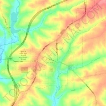
Name: Mineral Point topographic map, elevation, terrain.
Location: Mineral Point, Iowa County, Wisconsin, United States (42.84333 -90.21007 42.88394 -90.15772)
Average elevation: 1,063 ft
Minimum elevation: 902 ft
Maximum elevation: 1,194 ft
Iowa County trails, hiking, mountain biking, running and outdoor activities
Make a donation
Gear up for your next adventure:
As an Amazon Associate, this site earns from qualifying purchases at no extra cost to you.
Other topographic maps
Click on a map to view its topography, its elevation and its terrain.
Blue Mound State Park
United States > Wisconsin > Iowa County > Town of Brigham
Average elevation: 1,365 ft
Governor Dodge State Park
United States > Wisconsin > Iowa County > Town of Dodgeville
Average elevation: 1,102 ft
Tower Hill State Park
United States > Wisconsin > Iowa County > Spring Green
Average elevation: 764 ft