Geolocate

Juniper Springs topographic map

Click on the map to display elevation.

About this map

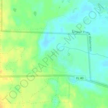
Name: Juniper Springs topographic map, elevation, terrain.

Location: Juniper Springs, Florida Trail, Marion County, Florida, United States (29.18365 -81.71246 29.18375 -81.71236)

Average elevation: 56 ft

Minimum elevation: 16 ft

Maximum elevation: 105 ft

Marion County trails, hiking, mountain biking, running and outdoor activities

Other topographic maps

Click on a map to view its topography, its elevation and its terrain.

McIntosh

United States > Florida > Marion County

Average elevation: 108 ft

Lake Bryant

United States > Florida > Marion County

Average elevation: 59 ft

Gear up for your next adventure:

🌎3D Topographic Globes - Raised relief globes for a tactile understanding of geography
📚Navigation Handbooks - Master the art of reading topographic maps and using a compass
🪶Wildlife Field Guides - Learn animal tracking and species ID
🛠️Outdoor Gear Repair Kit - Essential tools to fix gear on the trail
🥩Freeze-Dried Meals - Nutritious and lightweight food for remote expeditions

As an Amazon Associate, this site earns from qualifying purchases at no extra cost to you.