
Fort Frances topographic map
Click on the map to display elevation.
About this map
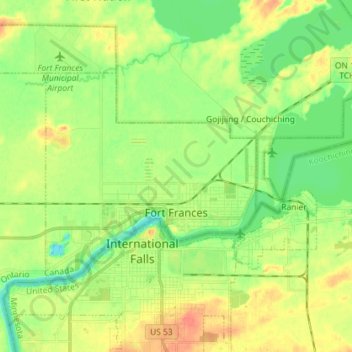
Name: Fort Frances topographic map, elevation, terrain.
Average elevation: 1,125 ft
Minimum elevation: 1,060 ft
Maximum elevation: 1,207 ft
Other topographic maps
Click on a map to view its topography, its elevation and its terrain.
Otukamamoan Lake
Canada > Ontario > Rainy River District > Unorganized Rainy River
Average elevation: 1,207 ft
Stratton
Canada > Ontario > Rainy River District > Morley Township > Stratton
Average elevation: 1,135 ft
Morson
Canada > Ontario > Rainy River District > Lake of the Woods Township
Average elevation: 1,079 ft
French River
Canada > Ontario > Rainy River District > Unorganized Rainy River
Average elevation: 1,440 ft
Little Eva Lake
Canada > Ontario > Rainy River District > Unorganized Rainy River
Average elevation: 1,171 ft
Helmet Lake
Canada > Ontario > Rainy River District > Unorganized Rainy River
Average elevation: 1,490 ft