Geolocate

Keady topographic map

Click on the map to display elevation.

About this map
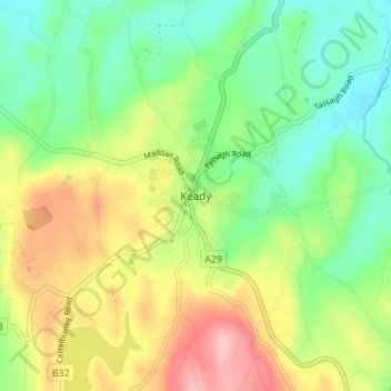
Name: Keady topographic map, elevation, terrain.

Location: Keady, Armagh City, Banbridge and Craigavon District, County Armagh, Northern Ireland, BT60 3TA, United Kingdom (54.20843 -6.74510 54.28843 -6.66510)

Average elevation: 512 ft

Minimum elevation: 233 ft

Maximum elevation: 919 ft

Other topographic maps

Click on a map to view its topography, its elevation and its terrain.
Lurgan

United Kingdom > Northern Ireland > County Armagh

Average elevation: 157 ft

Armagh

United Kingdom > Northern Ireland > County Armagh > Darkley

Average elevation: 328 ft

Canary

United Kingdom > Northern Ireland > County Armagh

Average elevation: 62 ft

Lurgan

United Kingdom > Northern Ireland > County Armagh

Average elevation: 157 ft

Kilmore

United Kingdom > Northern Ireland > County Armagh > Armagh

Average elevation: 108 ft

Armagh

United Kingdom > Northern Ireland > County Armagh > Armagh

Average elevation: 328 ft

Gear up for your next adventure:

☀️Outdoor Sunscreen - High protection sunscreen for outdoor activities
🍳Camping Cook Set - Complete cookware for outdoor meals
🚗GPS Dash Cams - Record your scenic drives through mountain passes and canyons
🌐World Map Poster - Decorative world maps with topographic info
🥘Titanium Cookware - Durable, featherlight pots and pans for backpacking

As an Amazon Associate, this site earns from qualifying purchases at no extra cost to you.