Geolocate

Eching topographic map

Click on the map to display elevation.

About this map

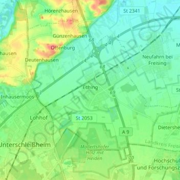
Name: Eching topographic map, elevation, terrain.

Location: Eching, Landkreis Freising, Bavaria, 85386, Germany (48.26572 11.57155 48.33155 11.69808)

Average elevation: 1,549 ft

Minimum elevation: 1,486 ft

Maximum elevation: 1,709 ft

Other topographic maps

Click on a map to view its topography, its elevation and its terrain.

Troll

Germany > Bavaria > Landkreis Freising > Moosburg > Moos

Average elevation: 1,394 ft

Seeberg

Germany > Bavaria > Landkreis Freising > Haag an der Amper

Average elevation: 1,545 ft

Günzenhausen

Germany > Bavaria > Landkreis Freising

Average elevation: 1,565 ft

Dietersheim

Germany > Bavaria > Landkreis Freising

Average elevation: 1,545 ft

Spörerau

Germany > Bavaria > Landkreis Freising > Wang

Average elevation: 1,345 ft

Mariabrunn

Germany > Bavaria > Landkreis Freising > Birkeneck

Average elevation: 1,486 ft

Gear up for your next adventure:

🔭Telescopic Hiking Pole - Adjustable pole for hiking stability
🧭Map Reading Tools - Tools and kits for map navigation
💧Water Purification System - Clean water on the trail with reliable purifiers
🗃️Trail First Aid Kit - Essential kit for outdoor injuries and emergencies
🔥Plasma Lighters - Windproof lighters that work in any weather condition

As an Amazon Associate, this site earns from qualifying purchases at no extra cost to you.