
Make a donation
Gear up for your next adventure:
As an Amazon Associate, this site earns from qualifying purchases at no extra cost to you.
San Gimignano topographic map
Click on the map to display elevation.
Make a donation
Gear up for your next adventure:
As an Amazon Associate, this site earns from qualifying purchases at no extra cost to you.
San Gimignano
The municipality of San Gimignano extends for 138 km² and is located on a hill in Val d'Elsa. The altitude difference is between a minimum of 64 meters a.s.l. in the plain of the river Elsa near Certaldo at a maximum of 631 meters in the area of Cornocchio.
Make a donation
Gear up for your next adventure:
As an Amazon Associate, this site earns from qualifying purchases at no extra cost to you.
About this map
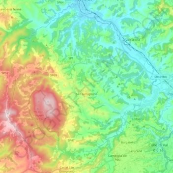
Name: San Gimignano topographic map, elevation, terrain.
Location: San Gimignano, Siena, Tuscany, Italy (43.40110 10.95083 43.54684 11.11296)
Average elevation: 784 ft
Minimum elevation: 210 ft
Maximum elevation: 2,057 ft
Make a donation
Gear up for your next adventure:
As an Amazon Associate, this site earns from qualifying purchases at no extra cost to you.
Other topographic maps
Click on a map to view its topography, its elevation and its terrain.
Make a donation
Gear up for your next adventure:
As an Amazon Associate, this site earns from qualifying purchases at no extra cost to you.
Make a donation
Gear up for your next adventure:
As an Amazon Associate, this site earns from qualifying purchases at no extra cost to you.
Mount Amiata
Italy > Tuscany > Siena > Abbadia San Salvatore
The region is included in the comuni of Abbadia San Salvatore, Arcidosso, Castel del Piano, Piancastagnaio, Santa Fiora and Seggiano, all located between 600 and 800 metres of altitude.
Average elevation: 4,675 ft
Make a donation
Gear up for your next adventure:
As an Amazon Associate, this site earns from qualifying purchases at no extra cost to you.