Geolocate

Abernathy topographic map

Click on the map to display elevation.

About this map

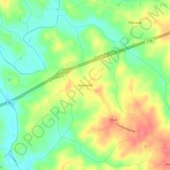
Name: Abernathy topographic map, elevation, terrain.

Location: Abernathy, Cleburne County, Alabama, United States (33.63066 -85.42745 33.67066 -85.38745)

Average elevation: 971 ft

Minimum elevation: 860 ft

Maximum elevation: 1,106 ft

Cleburne County trails, hiking, mountain biking, running and outdoor activities

Other topographic maps

Click on a map to view its topography, its elevation and its terrain.

Ranburne

United States > Alabama > Cleburne County

Average elevation: 994 ft

Edwardsville

United States > Alabama > Cleburne County

Average elevation: 965 ft

Heflin

United States > Alabama > Cleburne County

Average elevation: 991 ft

Fruithurst

United States > Alabama > Cleburne County

Average elevation: 1,083 ft

Gear up for your next adventure:

🧭Map Reading Tools - Tools and kits for map navigation
🔭Stargazing Telescopes - Perfect for camping in low-light pollution areas shown on maps
🧷Carabiner Set - Durable clips for gear attachment
🛰️Handheld GPS Units - Professional satellite navigators for precise backcountry mapping
🔥Plasma Lighters - Windproof lighters that work in any weather condition

As an Amazon Associate, this site earns from qualifying purchases at no extra cost to you.