
Make a donation
Gear up for your next adventure:
As an Amazon Associate, this site earns from qualifying purchases at no extra cost to you.
Hydetown topographic map
Click on the map to display elevation.
Make a donation
Gear up for your next adventure:
As an Amazon Associate, this site earns from qualifying purchases at no extra cost to you.
Hydetown
Hydetown Borough is located just south of the southern terminal moraine for glaciation in northwestern Pennsylvania. The borough is drained by Oil Creek, a southward-flowing tributary of the Allegheny River, which runs through the northwestern and southwestern sides of the borough and Thompson Creek, which enters from the northeast and joins the main creek southwest of the borough center. The lowest elevation in Hydetown is 1,220 ft (370 m) where Oil Creek flows south out of the borough. The highest elevation is 1,560 ft (480 m) at the eastern borough boundary.
Make a donation
Gear up for your next adventure:
As an Amazon Associate, this site earns from qualifying purchases at no extra cost to you.
About this map
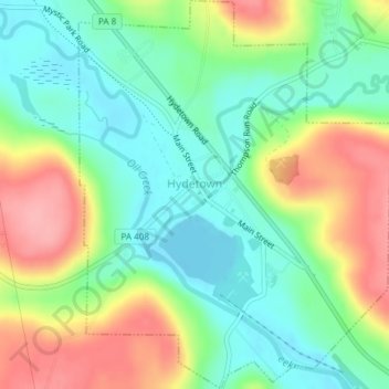
Name: Hydetown topographic map, elevation, terrain.
Average elevation: 1,352 ft
Minimum elevation: 1,207 ft
Maximum elevation: 1,578 ft
Crawford County trails, hiking, mountain biking, running and outdoor activities
Make a donation
Gear up for your next adventure:
As an Amazon Associate, this site earns from qualifying purchases at no extra cost to you.
Other topographic maps
Click on a map to view its topography, its elevation and its terrain.
Espyville
United States > Pennsylvania > Crawford County > Pymatuning Central
Average elevation: 1,047 ft