
Make a donation
Gear up for your next adventure:
As an Amazon Associate, this site earns from qualifying purchases at no extra cost to you.
Eyers Grove topographic map
Click on the map to display elevation.
Make a donation
Gear up for your next adventure:
As an Amazon Associate, this site earns from qualifying purchases at no extra cost to you.
About this map
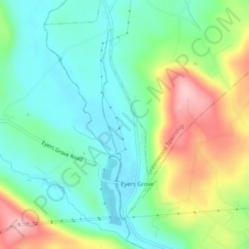
Name: Eyers Grove topographic map, elevation, terrain.
Location: Eyers Grove, Columbia County, Pennsylvania, United States (41.08475 -76.52223 41.10549 -76.51440)
Average elevation: 764 ft
Minimum elevation: 564 ft
Maximum elevation: 1,158 ft
Columbia County trails, hiking, mountain biking, running and outdoor activities
Make a donation
Gear up for your next adventure:
As an Amazon Associate, this site earns from qualifying purchases at no extra cost to you.
Other topographic maps
Click on a map to view its topography, its elevation and its terrain.
Mifflin Cross Roads
United States > Pennsylvania > Columbia County > Beaver Township
Average elevation: 1,024 ft
Make a donation
Gear up for your next adventure:
As an Amazon Associate, this site earns from qualifying purchases at no extra cost to you.
Byrnesville
United States > Pennsylvania > Columbia County > Conyngham Township
Average elevation: 1,325 ft
Hemlock Creek
United States > Pennsylvania > Columbia County > Buckhorn > Buckhorn
Average elevation: 679 ft