Geolocate

Alpine topographic map

Click on the map to display elevation.

Alpine

Located approximately 75 miles south of the Navajo Nation, Alpine was settled in 1876 by Anderson Bush, a European-American who built a log house there. He originally used it as a trading post known as "Fort Bush". Bush sold his holdings in 1879 to William Maxwell and Fred Hamblin, Mormon settlers who established the town as a Mormon community. They named the community for its lofty elevation.

Wikipedia (CC-BY-SA 3.0)

About this map

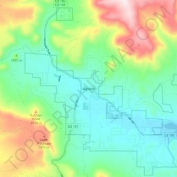
Name: Alpine topographic map, elevation, terrain.

Location: Alpine, Apache County, Arizona, 75920, United States (33.82839 -109.16466 33.86839 -109.12466)

Average elevation: 8,235 ft

Minimum elevation: 7,910 ft

Maximum elevation: 9,501 ft

Apache County trails, hiking, mountain biking, running and outdoor activities

Other topographic maps

Click on a map to view its topography, its elevation and its terrain.

Chinle

United States > Arizona > Apache County

Average elevation: 5,627 ft

Lyman Lake

United States > Arizona > Apache County

Average elevation: 6,115 ft

Ganado

United States > Arizona > Apache County

Average elevation: 6,522 ft

Pacheta Lake

United States > Arizona > Apache County

Average elevation: 8,301 ft

Bear Wallow Tank

United States > Arizona > Apache County

Average elevation: 8,176 ft

St. Michaels

United States > Arizona > Apache County

Average elevation: 6,778 ft

Burnside

United States > Arizona > Apache County

Average elevation: 6,447 ft

Eagar

United States > Arizona > Apache County

Average elevation: 7,306 ft

Chinle Agency

United States > Arizona > Apache County

Average elevation: 6,450 ft

Teec Nos Pos

United States > Arizona > Apache County

Average elevation: 5,315 ft

Round Rock

United States > Arizona > Apache County

Average elevation: 5,459 ft

Houck

United States > Arizona > Apache County

Average elevation: 6,201 ft

St. Johns

United States > Arizona > Apache County

Average elevation: 5,764 ft

Window Rock

United States > Arizona > Apache County

Window Rock is categorized as being within the 6a USDA hardiness zone, meaning the average annual extreme minimum temperature is between −10 and −5 °F (−23 and −21 °C). The city is cooler than most of Arizona due to its high elevation.

Average elevation: 6,837 ft

Fort Defiance Agency

United States > Arizona > Apache County

Average elevation: 6,276 ft

Gear up for your next adventure:

🧭Map Reading Tools - Tools and kits for map navigation
📚Navigation Handbooks - Master the art of reading topographic maps and using a compass
🌲Outdoor Survival Books - Best books on survival skills
🚁Photography Drones - Capture stunning aerial views of landforms and topography
📦Dry Bags Set - Waterproof storage for electronics and clothes

As an Amazon Associate, this site earns from qualifying purchases at no extra cost to you.