
Make a donation
Gear up for your next adventure:
As an Amazon Associate, this site earns from qualifying purchases at no extra cost to you.
Killala topographic map
Click on the map to display elevation.
Make a donation
Gear up for your next adventure:
As an Amazon Associate, this site earns from qualifying purchases at no extra cost to you.
Killala
The Roman Catholic Diocese of Killala (Alladenis in Latin) is one of the five suffragan sees of the ecclesiastical Province of Tuam, comprising the north-western part of the County Mayo with the Barony of Tireragh in the County Sligo. In all there are 22 parishes, some of which, bordering on the Atlantic Ocean, consist mostly of wild moorland, sparsely inhabited. Lewis's Topographical Dictionary sets down the length of the diocese as 45 miles (72 km), the breadth 21 mi (34 km), and the estimated superficies as 314,300 acres (1,272 km2) – of which 43,100 acres (174 km2) are in County Sligo and 271,200 acres (1,098 km2) in County Mayo.
Make a donation
Gear up for your next adventure:
As an Amazon Associate, this site earns from qualifying purchases at no extra cost to you.
About this map
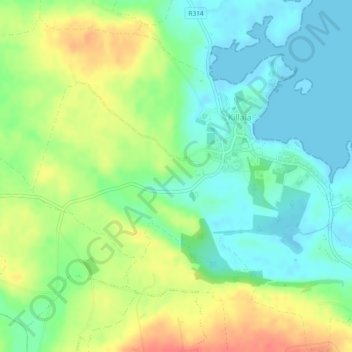
Name: Killala topographic map, elevation, terrain.
Average elevation: 69 ft
Minimum elevation: -3 ft
Maximum elevation: 171 ft
Make a donation
Gear up for your next adventure:
As an Amazon Associate, this site earns from qualifying purchases at no extra cost to you.
Other topographic maps
Click on a map to view its topography, its elevation and its terrain.
Make a donation
Gear up for your next adventure:
As an Amazon Associate, this site earns from qualifying purchases at no extra cost to you.
Make a donation
Gear up for your next adventure:
As an Amazon Associate, this site earns from qualifying purchases at no extra cost to you.
Make a donation
Gear up for your next adventure:
As an Amazon Associate, this site earns from qualifying purchases at no extra cost to you.