Geolocate

Cong topographic map

Click on the map to display elevation.

About this map
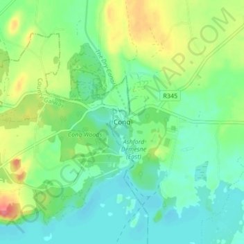
Name: Cong topographic map, elevation, terrain.

Location: Cong, Claremorris-Swinford Municipal District, County Mayo, Connacht, F31 XR57, Ireland (53.52080 -9.30594 53.56080 -9.26594)

Average elevation: 75 ft

Minimum elevation: 3 ft

Maximum elevation: 226 ft

Other topographic maps

Click on a map to view its topography, its elevation and its terrain.
Mayo

Ireland > County Mayo

Average elevation: 174 ft

Belmullet

Ireland > County Mayo

Average elevation: 30 ft

Killala

Ireland > County Mayo

The Roman Catholic Diocese of Killala (Alladenis in Latin) is one of the five suffragan sees of the ecclesiastical Province of Tuam, comprising the north-western part of the County Mayo with the Barony of Tireragh in the County Sligo. In all there are 22 parishes, some of which, bordering on the Atlantic…

Average elevation: 69 ft
Castlebar

Ireland > County Mayo

Average elevation: 144 ft

Cloghans

Ireland > County Mayo

Average elevation: 46 ft

Illanoona

Ireland > County Mayo

Average elevation: 66 ft

Tulrohaun

Ireland > County Mayo

Average elevation: 276 ft

Ballindine

Ireland > County Mayo

Average elevation: 203 ft

Inishowen

Ireland > County Mayo

Average elevation: 59 ft

Tawnyinah Upper

Ireland > County Mayo

Average elevation: 397 ft

Oory

Ireland > County Mayo

Average elevation: 154 ft

Saleen

Ireland > County Mayo

Average elevation: 112 ft

Garrankeel

Ireland > County Mayo

Average elevation: 66 ft

Gear up for your next adventure:

🥩Freeze-Dried Meals - Nutritious and lightweight food for remote expeditions
🕶️GPS Smartphone Mount - Secure mount for phone navigation
📦Dry Bags Set - Waterproof storage for electronics and clothes
🗺️NatGeo Topo Maps - High-quality waterproof printed topographic maps of US Parks
🛶Inflatable Kayak - Portable kayak for rivers, lakes, and expeditions

As an Amazon Associate, this site earns from qualifying purchases at no extra cost to you.