Geolocate

Gettysburg topographic map

Click on the map to display elevation.

About this map

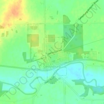
Name: Gettysburg topographic map, elevation, terrain.

Location: Gettysburg, Darke County, Ohio, 45328, United States (40.10782 -84.50348 40.12255 -84.48871)

Average elevation: 1,010 ft

Minimum elevation: 961 ft

Maximum elevation: 1,076 ft

Darke County trails, hiking, mountain biking, running and outdoor activities

Other topographic maps

Click on a map to view its topography, its elevation and its terrain.

Union Corners

United States > Ohio > Darke County

Average elevation: 1,010 ft

Webster

United States > Ohio > Darke County

Average elevation: 991 ft

Horatio

United States > Ohio > Darke County

Average elevation: 1,010 ft

Abbottsville

United States > Ohio > Darke County

Average elevation: 1,050 ft

Hill Grove

United States > Ohio > Darke County

Average elevation: 1,073 ft

Delisle

United States > Ohio > Darke County

Average elevation: 1,053 ft

Gear up for your next adventure:

🧯Portable Fire Pit - Compact fire pit for camping spots
❄️Traction Cleats - Prevent slips on icy trails during winter hikes
👓Polarized Sunglasses - Outdoor sunglasses for glare reduction
🏫Relief Map Kits - Hands-on tools for teaching landforms and elevation
🧦Merino Wool Socks - Moisture-wicking, blister-preventing socks for long treks

As an Amazon Associate, this site earns from qualifying purchases at no extra cost to you.