
Thank you for supporting this site ❤️
Make a donation
Make a donation
Gear up for your next adventure:
As an Amazon Associate, this site earns from qualifying purchases at no extra cost to you.
Binche topographic map
Click on the map to display elevation.
Thank you for supporting this site ❤️
Make a donation
Make a donation
Gear up for your next adventure:
As an Amazon Associate, this site earns from qualifying purchases at no extra cost to you.
About this map
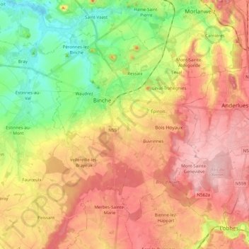
Name: Binche topographic map, elevation, terrain.
Location: Binche, La Louvière, Hainaut, Wallonia, Belgium (50.34933 4.05585 50.44688 4.25247)
Average elevation: 417 ft
Minimum elevation: 144 ft
Maximum elevation: 702 ft
Thank you for supporting this site ❤️
Make a donation
Make a donation
Gear up for your next adventure:
As an Amazon Associate, this site earns from qualifying purchases at no extra cost to you.
Other topographic maps
Click on a map to view its topography, its elevation and its terrain.
Houdeng-Gœgnies
Belgium > Hainaut > La Louvière > La Louvière > Houdeng-Gœgnies
Average elevation: 377 ft