
Make a donation
Gear up for your next adventure:
As an Amazon Associate, this site earns from qualifying purchases at no extra cost to you.
Tagliamento / Tiliment topographic map
Click on the map to display elevation.
Make a donation
Gear up for your next adventure:
As an Amazon Associate, this site earns from qualifying purchases at no extra cost to you.
About this map
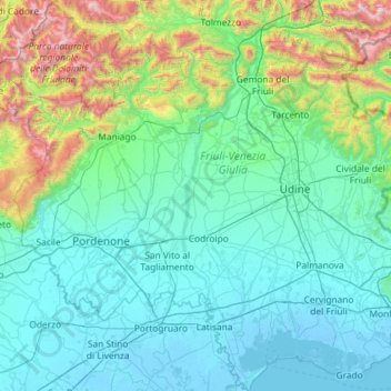
Name: Tagliamento / Tiliment topographic map, elevation, terrain.
Location: Tagliamento / Tiliment, Friuli-Venezia Giulia, Italy (45.64400 12.52147 46.44997 13.13929)
Average elevation: 1,280 ft
Minimum elevation: -20 ft
Maximum elevation: 8,855 ft
Make a donation
Gear up for your next adventure:
As an Amazon Associate, this site earns from qualifying purchases at no extra cost to you.
Other topographic maps
Click on a map to view its topography, its elevation and its terrain.
Sella Nevea
Italy > Friuli-Venezia Giulia > Udine > Chiusaforte
Sella Nevea (Friulian: Nevee, German: Neveasattel, Slovene: Na Žlebeh), at an altitude of 1,195 m (3,921 ft), is a high mountain pass in the Julian Alps, in the Friuli Venezia Giulia region of northeast Italy. Sella Nevea also lends its name to a frazione of the Chiusaforte municipality and the nearby…
Average elevation: 5,069 ft
Bagnoli della Rosandra / Boljunec
Italy > Friuli-Venezia Giulia > Trieste > San Dorligo della Valle / Dolina
Average elevation: 735 ft
Make a donation
Gear up for your next adventure:
As an Amazon Associate, this site earns from qualifying purchases at no extra cost to you.
Grotta a S del Monte Gurca
Italy > Friuli-Venezia Giulia > Trieste > Trieste > Opicina / Opčine
Average elevation: 584 ft
Make a donation
Gear up for your next adventure:
As an Amazon Associate, this site earns from qualifying purchases at no extra cost to you.
Canale Morto
Italy > Friuli-Venezia Giulia > San Canzian d'Isonzo > Isola Morosini
Average elevation: 7 ft
Make a donation
Gear up for your next adventure:
As an Amazon Associate, this site earns from qualifying purchases at no extra cost to you.
Cesclans
Italy > Friuli-Venezia Giulia > Udine > Cavazzo Carnico > Cesclans
Average elevation: 1,457 ft
Trinco / Trinko
Italy > Friuli-Venezia Giulia > Udine > Drenchia > Drenchia / Dreka > Trinco / Trinko
Average elevation: 2,434 ft
Make a donation
Gear up for your next adventure:
As an Amazon Associate, this site earns from qualifying purchases at no extra cost to you.