
Sointula topographic map
Click on the map to display elevation.
About this map
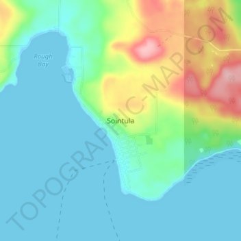
Name: Sointula topographic map, elevation, terrain.
Average elevation: 118 ft
Minimum elevation: 0 ft
Maximum elevation: 479 ft
Other topographic maps
Click on a map to view its topography, its elevation and its terrain.
Malcolm Island
Canada > British Columbia > Regional District of Mount Waddington > Area A (Seymour Inlet/Knight Inlet)
Average elevation: 69 ft
Maud Island
Canada > British Columbia > Regional District of Mount Waddington > Area A (Seymour Inlet/Knight Inlet)
Average elevation: 13 ft
Crib Island
Canada > British Columbia > Regional District of Mount Waddington > Area A (Seymour Inlet/Knight Inlet)
Average elevation: 20 ft
Glendale Cove
Canada > British Columbia > Regional District of Mount Waddington > Area A (Seymour Inlet/Knight Inlet) > Knight Inlet
Average elevation: 328 ft
Gilford Island
Canada > British Columbia > Regional District of Mount Waddington > Area A (Seymour Inlet/Knight Inlet)
Average elevation: 883 ft
Frederick Sound
Canada > British Columbia > Regional District of Mount Waddington > Area A (Seymour Inlet/Knight Inlet)
Average elevation: 1,230 ft
Klinaklini Glacier
Canada > British Columbia > Regional District of Mount Waddington > Area A (Seymour Inlet/Knight Inlet)
Average elevation: 5,180 ft
Kingcome Inlet
Canada > British Columbia > Regional District of Mount Waddington > Area A (Seymour Inlet/Knight Inlet)
Average elevation: 1,001 ft
Canyon Lake
Canada > British Columbia > Regional District of Mount Waddington > Area A (Seymour Inlet/Knight Inlet)
Average elevation: 1,637 ft
Approach Rock
Canada > British Columbia > Regional District of Mount Waddington > Area A (Seymour Inlet/Knight Inlet)
Average elevation: 75 ft
Mayor Island
Canada > British Columbia > Regional District of Mount Waddington > Area A (Seymour Inlet/Knight Inlet)
Average elevation: 16 ft
Skull Cove
Canada > British Columbia > Regional District of Mount Waddington > Area A (Seymour Inlet/Knight Inlet)
Average elevation: 52 ft