
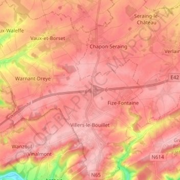
Villers-le-Bouillet topographic map
Interactive map
Click on the map to display elevation.
About this map
Name: Villers-le-Bouillet topographic map, elevation, terrain.
Location: Villers-le-Bouillet, Hoei, Luik, Wallonië, 4530, België (50.55133 5.18961 50.62975 5.29730)
Average elevation: 568 ft
Minimum elevation: 249 ft
Maximum elevation: 676 ft
Other topographic maps
Click on a map to view its topography, its elevation and its terrain.
Les Gottes
Les Gottes, Modave, Hoei, Luik, Wallonië, 4577, België
Average elevation: 758 ft
Seraing-le-Château
Seraing-le-Château, Verlaine, Hoei, Luik, Wallonië, 4537, België
Average elevation: 558 ft
Vyle-et-Tharoul
Vyle-et-Tharoul, Marchin, Hoei, Luik, Wallonië, 4570, België
Average elevation: 735 ft
La Sarte à Ben
La Sarte à Ben, Hoei, Luik, Wallonië, 4500, België
Average elevation: 568 ft
Burnontige
Burnontige, Ferrières, Hoei, Luik, Wallonië, 4190, België
Average elevation: 1,211 ft
Comblain-la-Tour
Comblain-la-Tour, Hamoir, Hoei, Luik, Wallonië, 4180, België
Average elevation: 627 ft
Warnant-Dreye
België > Luik > Hoei > Warnant-Dreye
Warnant-Dreye, Hoei, Luik, Wallonië, 4530, België
Average elevation: 541 ft
Villers-le-Temple
Villers-le-Temple, Nandrin, Hoei, Luik, Wallonië, 4550, België
Average elevation: 778 ft
Vaux-et-Borset
Vaux-et-Borset, Villers-le-Bouillet, Hoei, Luik, Wallonië, 4530, België
Average elevation: 545 ft
Chapon-Seraing
Chapon-Seraing, Verlaine, Hoei, Luik, Wallonië, 4537, België
Average elevation: 591 ft
Vieuxville
Vieuxville, Ferrières, Hoei, Luik, Wallonië, 4190, België
Average elevation: 705 ft
Fize-Fontaine
Fize-Fontaine, Villers-le-Bouillet, Hoei, Luik, Wallonië, 4530, België
Average elevation: 600 ft
Vieux-Waleffe
Vieux-Waleffe, Villers-le-Bouillet, Hoei, Luik, Wallonië, 4530, België
Average elevation: 495 ft