Geolocate

Norma topographic map

Click on the map to display elevation.

About this map

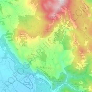
Name: Norma topographic map, elevation, terrain.

Location: Norma, Latina, Lazio, 04010, Italy (41.57053 12.92753 41.64080 13.02528)

Average elevation: 1,598 ft

Minimum elevation: 62 ft

Maximum elevation: 4,337 ft

Other topographic maps

Click on a map to view its topography, its elevation and its terrain.

Borgo Bainsizza

Italy > Lazio > Latina > Latina

Average elevation: 89 ft

Le Cupe

Italy > Lazio > Latina > Itri

Average elevation: 1,043 ft

Campoleone Scalo

Italy > Lazio > Latina > Aprilia

Average elevation: 407 ft

Gear up for your next adventure:

🔥Camping Stove - Portable stove for camping and backcountry cooking
🦶Hiking Gaiters - Keep debris and water out of your boots
👟Men's Trail Runners - Lightweight footwear for fast-paced exploration and light hiking
🧣Hiking Neck Gaiter - Multi‑use neck protection for outdoor weather
🛌Ultralight Sleeping Bags - Compact down bags for cold nights in the wilderness

As an Amazon Associate, this site earns from qualifying purchases at no extra cost to you.