
Las Quintas Fronterizas topographic map
Interactive map
Click on the map to display elevation.
About this map
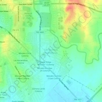
Name: Las Quintas Fronterizas topographic map, elevation, terrain.
Average elevation: 778 ft
Minimum elevation: 719 ft
Maximum elevation: 886 ft
Other topographic maps
Click on a map to view its topography, its elevation and its terrain.
Eagle Pass
United States > Texas > Maverick County
Eagle Pass, Maverick County, Texas, 78852, United States
Average elevation: 758 ft
El Indio
United States > Texas > Maverick County
El Indio, Maverick County, Texas, 78860, United States
Average elevation: 728 ft
Victoriano Hernandez Colonia
United States > Texas > Maverick County > Rosita
Victoriano Hernandez Colonia, Rosita, Maverick County, Texas, United States
Average elevation: 722 ft