
Thank you for supporting this site ❤️
Make a donation
Make a donation
Gear up for your next adventure:
As an Amazon Associate, this site earns from qualifying purchases at no extra cost to you.
Enchant topographic map
Click on the map to display elevation.
Thank you for supporting this site ❤️
Make a donation
Make a donation
Gear up for your next adventure:
As an Amazon Associate, this site earns from qualifying purchases at no extra cost to you.
About this map
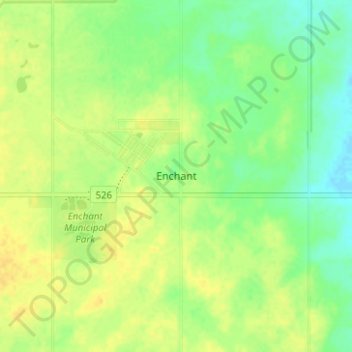
Name: Enchant topographic map, elevation, terrain.
Location: Enchant, Municipal District of Taber, Alberta, Canada (50.14667 -112.43667 50.18667 -112.39667)
Average elevation: 2,654 ft
Minimum elevation: 2,612 ft
Maximum elevation: 2,687 ft
Thank you for supporting this site ❤️
Make a donation
Make a donation
Gear up for your next adventure:
As an Amazon Associate, this site earns from qualifying purchases at no extra cost to you.