
Make a donation
Gear up for your next adventure:
As an Amazon Associate, this site earns from qualifying purchases at no extra cost to you.
Warm Springs topographic map
Click on the map to display elevation.
Make a donation
Gear up for your next adventure:
As an Amazon Associate, this site earns from qualifying purchases at no extra cost to you.
Warm Springs
Warm Springs is located in southern Meriwether County at 32°53′19″N 84°40′48″W / 32.88861°N 84.68000°W / 32.88861; -84.68000 (32.888689, −84.680089). It is bordered to the south by Talbot County and to the west by F. D. Roosevelt State Park, including the Little White House. Pine Mountain rises to an elevation of 1,340 feet (410 m) south of the city, about 400 feet (120 m) higher than the city center.
Make a donation
Gear up for your next adventure:
As an Amazon Associate, this site earns from qualifying purchases at no extra cost to you.
About this map
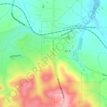
Name: Warm Springs topographic map, elevation, terrain.
Location: Warm Springs, Meriwether County, Georgia, United States (32.86937 -84.68550 32.90197 -84.66666)
Average elevation: 968 ft
Minimum elevation: 791 ft
Maximum elevation: 1,266 ft
Meriwether County trails, hiking, mountain biking, running and outdoor activities
Make a donation
Gear up for your next adventure:
As an Amazon Associate, this site earns from qualifying purchases at no extra cost to you.
Other topographic maps
Click on a map to view its topography, its elevation and its terrain.