
Sudbury topographic map
Click on the map to display elevation.
About this map
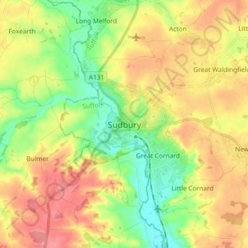
Name: Sudbury topographic map, elevation, terrain.
Location: Sudbury, Babergh, Suffolk, England, CO10 1GL, United Kingdom (52.00015 0.68995 52.08015 0.76995)
Average elevation: 177 ft
Minimum elevation: 56 ft
Maximum elevation: 305 ft
Other topographic maps
Click on a map to view its topography, its elevation and its terrain.
Long Melford-Bury St Edmunds branch line
United Kingdom > England > Suffolk > Babergh > Lavenham
Average elevation: 230 ft