
Tankerton topographic map
Click on the map to display elevation.
About this map
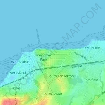
Name: Tankerton topographic map, elevation, terrain.
Location: Tankerton, Canterbury, Kent, England, CT5 2AN, United Kingdom (51.34411 1.02386 51.38411 1.06386)
Average elevation: 26 ft
Minimum elevation: -3 ft
Maximum elevation: 194 ft
Other topographic maps
Click on a map to view its topography, its elevation and its terrain.
Reculver Country Park
United Kingdom > England > Kent > Canterbury > Hillborough
Average elevation: 33 ft