
Make a donation
Gear up for your next adventure:
As an Amazon Associate, this site earns from qualifying purchases at no extra cost to you.
Mangabe topographic map
Click on the map to display elevation.
Make a donation
Gear up for your next adventure:
As an Amazon Associate, this site earns from qualifying purchases at no extra cost to you.
About this map
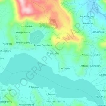
Name: Mangabe topographic map, elevation, terrain.
Location: Mangabe, Itasy, Province d’Antananarivo, Madagascar (-19.04174 46.73952 -19.00174 46.77952)
Average elevation: 4,144 ft
Minimum elevation: 3,904 ft
Maximum elevation: 4,928 ft
Make a donation
Gear up for your next adventure:
As an Amazon Associate, this site earns from qualifying purchases at no extra cost to you.
Other topographic maps
Click on a map to view its topography, its elevation and its terrain.
Make a donation
Gear up for your next adventure:
As an Amazon Associate, this site earns from qualifying purchases at no extra cost to you.
Soavinandriana
En termes de relief Nord au Nord Est plateaux élevés à caractère volcanique ; du Sud au Sud Ouest plateaux de basse altitude. Le point culminant est à 1806 m (Ambohitrimanjaka, Commune de Soavinandriana) et le point le plus bas à 763 m (Ambohimanarivo, Commune Tamponala).
Average elevation: 4,541 ft