
Upper Moreland Township topographic map
Interactive map
Click on the map to display elevation.
About this map
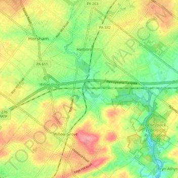
Name: Upper Moreland Township topographic map, elevation, terrain.
Average elevation: 272 ft
Minimum elevation: 125 ft
Maximum elevation: 440 ft
Other topographic maps
Click on a map to view its topography, its elevation and its terrain.
Maple Glen
United States > Pennsylvania > Montgomery County > Upper Dublin Township
Maple Glen, Upper Dublin Township, Montgomery County, Pennsylvania, 19002, United States
Average elevation: 335 ft
Worcester
United States > Pennsylvania > Montgomery County > Worcester Township
Worcester, Worcester Township, Montgomery County, Pennsylvania, 19490, United States
Average elevation: 305 ft
Perkiomen Township
United States > Pennsylvania > Montgomery County
Perkiomen Township, Montgomery County, Pennsylvania, 19473, United States
Average elevation: 249 ft
Hidden Valley
United States > Pennsylvania > Montgomery County > Upper Merion Township > King of Prussia
Hidden Valley, King of Prussia, Upper Merion Township, Montgomery County, Pennsylvania, 19406, United States
Average elevation: 154 ft
Willow Grove
United States > Pennsylvania > Montgomery County > Upper Moreland Township
Willow Grove, Upper Moreland Township, Montgomery County, Pennsylvania, 19090, United States
Average elevation: 299 ft
Roslyn
United States > Pennsylvania > Montgomery County > Abington Township
Roslyn, Abington Township, Montgomery County, Pennsylvania, 19001, United States
Average elevation: 308 ft
Lafayette Park
United States > Pennsylvania > Montgomery County > Upper Merion Township > King of Prussia
Lafayette Park, King of Prussia, Upper Merion Township, Montgomery County, Pennsylvania, 19406, United States
Average elevation: 177 ft
Rydal Park
United States > Pennsylvania > Montgomery County > Abington Township
Rydal Park, Abington Township, Montgomery County, Pennsylvania, 19046, United States
Average elevation: 285 ft
Three Tuns
United States > Pennsylvania > Montgomery County > Upper Dublin Township
Three Tuns, Upper Dublin Township, Montgomery County, Pennsylvania, 19002, United States
Average elevation: 331 ft
Springtown
United States > Pennsylvania > Montgomery County > East Norriton Township
Springtown, East Norriton Township, Montgomery County, Pennsylvania, 19462, United States
Average elevation: 243 ft
Horsham
United States > Pennsylvania > Montgomery County > Horsham Township
Horsham, Horsham Township, Montgomery County, Pennsylvania, 19044, United States
Average elevation: 292 ft
Enfield
United States > Pennsylvania > Montgomery County > Springfield Township
Enfield, Springfield Township, Montgomery County, Pennsylvania, 19031, United States
Average elevation: 285 ft
Orvilla
United States > Pennsylvania > Montgomery County > Hatfield Township
Orvilla, Hatfield Township, Montgomery County, Pennsylvania, 19440, United States
Average elevation: 328 ft
Bob White Farms
United States > Pennsylvania > Montgomery County > Upper Merion Township
Bob White Farms, Upper Merion Township, Montgomery County, Pennsylvania, 19097, United States
Average elevation: 312 ft
Hatfield Township
United States > Pennsylvania > Montgomery County
Hatfield Township, Montgomery County, Pennsylvania, United States
Average elevation: 364 ft
Mount Vernon Gardens
United States > Pennsylvania > Montgomery County > Abington Township
Mount Vernon Gardens, Abington Township, Montgomery County, Pennsylvania, 19001, United States
Average elevation: 305 ft
Lower Providence Township
United States > Pennsylvania > Montgomery County
Lower Providence Township, Montgomery County, Pennsylvania, United States
Average elevation: 230 ft
Conshohocken
United States > Pennsylvania > Montgomery County > Conshohocken
Conshohocken, Montgomery County, Pennsylvania, 19428, United States
Average elevation: 151 ft
West Conshohocken
United States > Pennsylvania > Montgomery County
West Conshohocken, Montgomery County, Pennsylvania, United States
Average elevation: 190 ft
Wyncote
United States > Pennsylvania > Montgomery County > Cheltenham Township
Wyncote, Cheltenham Township, Montgomery County, Pennsylvania, 19095, United States
Average elevation: 302 ft
Upper Dublin Township
United States > Pennsylvania > Montgomery County
Upper Dublin Township, Montgomery County, Pennsylvania, United States
Average elevation: 285 ft
Willowmere
United States > Pennsylvania > Montgomery County > Ambler
Willowmere, Ambler, Montgomery County, Pennsylvania, 19002, United States
Average elevation: 269 ft
King of Prussia
United States > Pennsylvania > Montgomery County > Upper Merion Township
King of Prussia, Upper Merion Township, Montgomery County, Pennsylvania, 19406, United States
Average elevation: 194 ft
Collegeville
United States > Pennsylvania > Montgomery County
Collegeville, Montgomery County, Pennsylvania, 19426, United States
Average elevation: 184 ft
Wissahickon Valley Park
United States > Pennsylvania > Montgomery County > Philadelphia
Wissahickon Valley Park, Philadelphia, Montgomery County, Pennsylvania, United States
Average elevation: 253 ft
Fairoaks
United States > Pennsylvania > Montgomery County > Horsham Township > Horsham
Fairoaks, Horsham, Horsham Township, Montgomery County, Pennsylvania, 19040, United States
Average elevation: 276 ft
Montgomery Township
United States > Pennsylvania > Montgomery County
Montgomery Township, Montgomery County, Pennsylvania, United States
Average elevation: 377 ft
Cynwyd Estates
United States > Pennsylvania > Montgomery County > Lower Merion Township
Cynwyd Estates, Lower Merion Township, Montgomery County, Pennsylvania, 19066, United States
Average elevation: 262 ft
Abington Township
United States > Pennsylvania > Montgomery County
Abington Township, Montgomery County, Pennsylvania, United States
Average elevation: 266 ft
Audubon
United States > Pennsylvania > Montgomery County > Lower Providence Township
Audubon, Lower Providence Township, Montgomery County, Pennsylvania, United States
Average elevation: 207 ft
Lansdale
United States > Pennsylvania > Montgomery County
Lansdale, Montgomery County, Pennsylvania, United States
Average elevation: 354 ft
Hanover Court
United States > Pennsylvania > Montgomery County > Pottstown
Hanover Court, Pottstown, Montgomery County, Pennsylvania, 19464, United States
Average elevation: 210 ft
Norristown
United States > Pennsylvania > Montgomery County
Norristown, Montgomery County, Pennsylvania, 19401, United States
Average elevation: 164 ft
Perkiomenville
United States > Pennsylvania > Montgomery County > Marlborough Township
Perkiomenville, Marlborough Township, Montgomery County, Pennsylvania, 18074, United States
Average elevation: 318 ft
Lower Moreland Township
United States > Pennsylvania > Montgomery County
Lower Moreland Township, Montgomery County, Pennsylvania, 19006, United States
Average elevation: 223 ft
Limerick Township
United States > Pennsylvania > Montgomery County
Limerick Township, Montgomery County, Pennsylvania, 19468, United States
Average elevation: 276 ft
Wynmere Downs
United States > Pennsylvania > Montgomery County > Horsham Township
Wynmere Downs, Horsham Township, Montgomery County, Pennsylvania, 19044, United States
Average elevation: 322 ft
Jenkintown
United States > Pennsylvania > Montgomery County
Jenkintown, Montgomery County, Pennsylvania, United States
Average elevation: 279 ft
Ambler
United States > Pennsylvania > Montgomery County
Ambler, Montgomery County, Pennsylvania, United States
Average elevation: 249 ft
North Wales
United States > Pennsylvania > Montgomery County
North Wales, Montgomery County, Pennsylvania, United States
Average elevation: 371 ft
Mount Pleasant
United States > Pennsylvania > Montgomery County > Whitpain Township
Mount Pleasant, Whitpain Township, Montgomery County, Pennsylvania, 19002, United States
Average elevation: 256 ft
Meadowbrook
United States > Pennsylvania > Montgomery County > Abington Township
Meadowbrook, Abington Township, Montgomery County, Pennsylvania, 19006, United States
Average elevation: 217 ft
Green Lane Reservoir
United States > Pennsylvania > Montgomery County > Upper Hanover Township
Green Lane Reservoir, Upper Hanover Township, Montgomery County, Pennsylvania, United States
Average elevation: 377 ft
Lower Gwynedd Township
United States > Pennsylvania > Montgomery County
Lower Gwynedd Township, Montgomery County, Pennsylvania, United States
Average elevation: 328 ft
Skippack Township
United States > Pennsylvania > Montgomery County
Skippack Township, Montgomery County, Pennsylvania, United States
Average elevation: 230 ft
Lower Salford Township
United States > Pennsylvania > Montgomery County
Lower Salford Township, Montgomery County, Pennsylvania, United States
Average elevation: 272 ft
Whitemarsh Township
United States > Pennsylvania > Montgomery County
Whitemarsh Township, Montgomery County, Pennsylvania, 19444, United States
Average elevation: 262 ft
Bridgeport
United States > Pennsylvania > Montgomery County
Bridgeport, Montgomery County, Pennsylvania, 19405, United States
Average elevation: 112 ft
Harleysville
United States > Pennsylvania > Montgomery County > Lower Salford Township
Harleysville, Lower Salford Township, Montgomery County, Pennsylvania, 19438, United States
Average elevation: 299 ft
Royersford
United States > Pennsylvania > Montgomery County
Royersford, Montgomery County, Pennsylvania, United States
Average elevation: 174 ft