
Ruiru topographic map
Click on the map to display elevation.
About this map
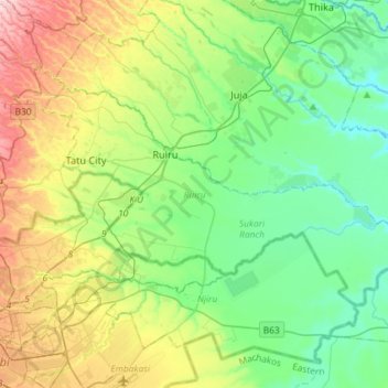
Name: Ruiru topographic map, elevation, terrain.
Location: Ruiru, Kiambu, Central Kenya, Kenya (-1.26021 36.86860 -1.09441 37.15973)
Average elevation: 5,072 ft
Minimum elevation: 4,698 ft
Maximum elevation: 5,922 ft
Other topographic maps
Click on a map to view its topography, its elevation and its terrain.
Kijabe
Kenya > Kiambu > Lari > Kinale ward
It stands on the edge of the Great Rift Valley at an altitude of 2200m, some 50 kilometres north-west of Nairobi. Kijabe is located in the sub-county of Lari, Kiambu County. Kijabe has a population 2,026 in 2019. Kijabe has a railway station along the Uganda Railway. The town is located between Limuru and…
Average elevation: 7,582 ft
Ruiru
Ruiru is located about 20 kilometres (12 mi), by road, northeast of the central business district of Nairobi, the nation's capital city. The subcounty measures 292 km2 (113 sq mi) and is connected to Nairobi by both road and rail. The geographical co-ordinates of Ruiru are: 1°10'04.0"S, 36°58'24.0"E…
Average elevation: 5,016 ft
Ruiru
Kenya > Kiambu > Ruiru > Biashara ward
Ruiru is about 20 kilometres (12 mi) by road northeast of the central business district of Nairobi, the nation's capital city. The sub-county measures 292 km2 (113 sq mi) and is connected to Nairobi by road and rail. The geographical coordinates of Ruiru are 1°10'04.0"S, 36°58'24.0" E (Latitude: −1.167778;…
Average elevation: 5,023 ft
Limuru
Most of the area of Limuru is now what was previously known as the "white highlands", a rich agricultural land south of the equator. The term "white highlands" derived from the British and other Europeans who realised the productive potential of this area and settled in large numbers with the support of the…
Average elevation: 7,395 ft
Limuru
Limuru encompasses areas previously known as the "white highlands," a rich agricultural land south of the equator. The term "white highlands" derived from the British and other Europeans who realised the productive potential of this area and settled in large numbers with the support of the colonial government,…
Average elevation: 7,395 ft